
St Michael's Mount
Background to the schools Wikipedia
SOS Children volunteers helped choose articles and made other curriculum material SOS Children is the world's largest charity giving orphaned and abandoned children the chance of family life.
Coordinates: 50.1160°N 5.4772°W
| St Michael's Mount | |
| Cornish: Karrek Loos y'n Koos | |
 St Michael's Mount |
|
 St Michael's Mount
|
|
| Area | 0.09 sq mi (0.23 km2) |
|---|---|
| OS grid reference | SW514298 |
| - London | 290 miles (467 km) |
| Civil parish | St Michael's Mount |
| Unitary authority | Cornwall |
| Ceremonial county | Cornwall |
| Region | South West |
| Country | England |
| Sovereign state | United Kingdom |
| Post town | MARAZION |
| Postcode district | TR17 |
| Dialling code | 01736 |
| Police | Devon and Cornwall |
| Fire | Cornwall |
| Ambulance | South Western |
| EU Parliament | South West England |
| UK Parliament | St Ives |
| Website | http://www.stmichaelsmount.co.uk/ |
|
|
St Michael's Mount ( Cornish: Karrek Loos y'n Koos, meaning "grey rock in the woods") is a tidal island located 366 metres (400 yards) off the Mount's Bay coast of Cornwall, England, United Kingdom. It is a civil parish and is united with the town of Marazion by a man-made causeway of granite setts, passable between mid-tide and low water.
The island exhibits a combination of slate and granite (see Geology below). Its Cornish language name — literally, "the grey rock in the wood" — may represent a folk memory of a time before Mount's Bay was flooded. Certainly, the Cornish name would be an accurate description of the Mount set in woodland. Remains of trees have been seen at low tides following storms on the beach at Perranuthnoe, but radiocarbon dating established the submerging of the hazel wood at about 1700 BC. The chronicler John of Worcester relates under the year 1099 that St. Michael's Mount was located five or six miles (10 km) from the sea, enclosed in a thick wood, but that on the third day of the nones of November the sea overflowed the land, destroying many towns and drowning many people as well as innumerable oxen and sheep; the Anglo-Saxon Chronicle records under the date 11 November 1099, "The sea-flood sprung up to such a height, and did so much harm, as no man remembered that it ever did before". The Cornish legend of Lyonesse, an ancient kingdom said to have extended from Penwith toward the Isles of Scilly, also talks of land being inundated by the sea.
In prehistoric times, St Michael's Mount may have been a port for the tin trade, and Gavin de Beer made a case for it to be identified with the "tin port" Ictis/Ictin mentioned by Posidonius.
Historically, St Michael's Mount was a Cornish counterpart of Mont Saint-Michel in Normandy, France (which shares the same tidal island characteristics and the same conical shape), when it was given to the Benedictines, religious order of Mont Saint-Michel, by Edward the Confessor in the 11th century.
St Michael's Mount is known colloquially by locals as simply the Mount.
St Michael's Mount is one of 43 (unbridged) tidal islands which can be walked to from the mainland of England, Scotland and Wales. (15)
History

The Mount may be the Mictis of Timaeus, mentioned by Pliny the Elder in his Naturalis Historia (IV:XVI.104), and the Ictis of Diodorus Siculus. Both men had access to the now lost texts of the ancient Greek geographer Pytheas, who visited the island in the fourth century BC. If this is true, it is one of the earliest identified locations in the whole of western Europe and particularly on the island of Britain.
In the fifth century A.D., it is claimed that St. Michael, the Archangel appeared to local fishermen on the Mount, which according to author Richard Freeman Johnson is perhaps a nationalistic twist to a myth.
It may have been the site of a monastery in the 8th - early 11th centuries and Edward the Confessor gave it to the Norman abbey of Mont Saint-Michel. It was a priory of that abbey until the dissolution of the alien houses by Henry V, when it was given to the abbess and Convent of Syon at Isleworth, Middlesex. It was a resort of pilgrims, whose devotions were encouraged by an indulgence granted by Pope Gregory in the 11th century.
The monastic buildings were built during the 12th century and in 1275 an earthquake destroyed the original priory church, which was rebuilt in the late 14th century. It is still in use today. The priory was seized by the Crown, when Henry V went to war in France and it became part of the endowment for the Brigittine Abbey of Syon at Twickenham in 1424. Thus ended the connection with Mont St Michel.
Henry Pomeroy captured the Mount, on behalf of Prince John, in the reign of Richard I. John de Vere, 13th Earl of Oxford, seized and held it during a siege of 23 weeks against 6,000 of Edward IV's troops in 1473. Perkin Warbeck occupied the Mount in 1497. Humphry Arundell, governor of St Michael's Mount, led the rebellion of 1549. During the reign of Queen Elizabeth I, it was given to Robert Cecil, Earl of Salisbury, by whose son it was sold to Sir Francis Basset. During the Civil War, Sir Arthur Basset, brother of Sir Francis, held the Mount against the parliament until July 1646.
In 1755 the Lisbon earthquake caused a tsunami to strike the Cornish coast over 1,000 miles (1,600 km) away. The sea rose six feet in 10 minutes at St Michael's Mount, ebbed at the same rate, and continued to rise and fall for five hours. The 19th-century French writer Arnold Boscowitz claimed that "great loss of life and property occurred upon the coasts of Cornwall."
In the late 19th century the skeleton of an anchorite was discovered when a chamber was found beneath the castle's chapel. When the anchorite died of illness or natural causes, the chamber had been sealed off to become his tomb. The Mount was sold in 1659 to Colonel John St Aubyn. His descendant, Lord St Levan, continues to be the "tenant" of the Mount but has ceased to be resident there, his nephew, James St Aubyn, taking up residency and management of the Mount in 2004.
Little is known about the village before the beginning of 18th century, save that there were a few fishermen's cottages and monastic cottages. After improvements to the harbour in 1727, St Michael's Mount became a flourishing seaport, and by 1811 there were 53 houses and four streets. The pier was extended in 1821 and the population peaked in the same year, when the island had 221 people. There were three schools, a Wesleyan chapel, and three public houses, mostly used by visiting sailors. The village went into decline following major improvements to nearby Penzance harbour and the extension of the railway to Penzance in 1852, and many of the houses and buildings were demolished.
The Mount was fortified during the Second World War during the invasion crisis of 1940-41. Three pillboxes can be seen to this day.
Sixty-five years after the Second World War, it was suggested based on interviews with contemporaries that the former Nazi foreign minister and one time ambassador to Britain, Joachim von Ribbentrop, had wanted to live on the Mount after the planned German conquest. Archived documents revealed that during his time in Britain in the 1930s, in which he had initially proposed an alliance with Nazi Germany, Ribbentrop frequently visited Cornwall.
In 1954, the 3rd Baron St Levan gave most of St Michael’s Mount to the National Trust, together with a large endowment fund. The St Aubyn family retained a 999-year lease to inhabit the castle and a licence to manage the public viewing of its historic rooms. This is managed in conjunction with the National Trust.
Local government

Until recent times both the Mount and the town of Marazion formed part of the parish of St Hilary. St Michael's Mount forms its own civil parish for local government purposes. Currently, this takes the form of a parish meeting as opposed to a parish council (that is, a yearly meeting of electors that does not elect councillors). The current chairman of the St Michael's Mount parish meeting is James St Aubyn.
The island today
The chapel is extra- diocesan, and the castle is the official residence of Lord St Levan. Many relics, chiefly armour and antique furniture, are preserved in the castle. The chapel of St Michael, a fifteenth century building, has an embattled tower, in one angle of which is a small turret, which served for the guidance of ships. Chapel Rock, on the beach, marks the site of a shrine dedicated to the Virgin Mary, where pilgrims paused to worship before ascending the Mount. A few houses are built on the hillside facing Marazion, and a spring supplies them with water.
Some studies indicate that any rise in ocean waters as well as existing natural erosion would put some of the Cornwall coast at risk, including St. Michael's Mount.
There is a row of eight houses at the back of the present village; they were built in 1885 and are known as Elizabeth Terrace. A spring supplies them with water. Some of the houses are occupied by staff working in the castle and elsewhere on the island.
The island cemetery (currently no public access) contains the graves of former residents of the island and several drowned sailors. There are also buildings that were formerly the steward's house, a changing-room for bathers, the stables, the laundry, a barge house, a sail loft (now a restaurant), and two former inns. A former bowling green adjoins one of the buildings.
One of the most noteworthy points of interest on the island is the island's own underground railway, which is still used to transport goods from the harbour up to the castle. It was built by tin miners around 1900, replacing the pack horses which had previously been used. Due to the steep gradient, it cannot be used for passengers. The National Trust currently does not permit public access or viewing of the railway.
The harbour, widened in 1823 to allow vessels of 500 tons to enter, has a pier dating from the fifteenth century which was subsequently enlarged and restored. Queen Victoria landed at the harbour from the royal yacht in 1846, and a brass inlay of her footstep can be seen at the top of the landing stage. King Edward VII's footstep is also visible near the bowling-green. In 1967 the Queen Mother entered the harbour in a pinnace from the royal yacht Britannia.
Geology
The rock exposures around St Michael's Mount provide an opportunity to see many features of the geology of Cornwall in a single locality. The mount is made of the uppermost part of a granite intrusion into metamorphosed Devonian mudstones or pelites. The granite is itself mineralised with a well-developed sheeted greisen vein system. Due to its geology the southern coast of the island was designated a Site of Special Scientific Interest in 1995.
Granites
There are two types of granite visible on the mount. Most of the intrusion is a tourmaline muscovite granite which is variably porphyritic. This is separated from a biotite muscovite granite by pegmatites.
Devonian Pelites
Originally laid down as mudstones these pelites were regionally metamorphosed and deformed (mainly folded here) by the Variscan orogeny. They were then affected by the intrusion of the granite, which caused further contact metamorphism, locally forming a hornfels, and mineralisation.
Mineralisation
The best developed mineralisation is found within the uppermost part of the granite itself in the form of sheeted greisen veins. These steep W-E trending veins are thought to have formed by hydraulic fracturing when the fluid pressure at the top of the granite reached a critical level. The granite was fractured and the fluids altered the granite by replacing feldspars with quartz and muscovite. The fluids were also rich in boron, tin and tungsten and tourmaline, wolframite and cassiterite are common in the greisen veins. As the area cooled the veins became open to fluids from the surrounding country rock and these deposited sulphides e.g. chalcopyrite and stannite. Greisen veins are also locally developed within the pelites.
In popular culture
"Mt Saint Michel Mix + Saint Michaels Mount" is the title of an experimental electronic track by musician Aphex Twin, who grew up in Cornwall.
St Michael's Mount was one of the locations featured in the BBC One "Balloon" Idents.
St Michael's Mount was used in the 1979 film Dracula as Castle Dracula and also in the 2003 film Johnny English as the exterior of the character Pascal Sauvage's French chateau.
In the 1983 James Bond film Never Say Never Again, two guided missiles armed with nuclear warheads fly over the English countryside and out to sea, passing directly over St Michael's Mount.
In Michael Moorcock's series of Fantasy novels about Prince Corum, a fictionalised version of St Michael's Mount appears as Moidel's Mount.
In the Spring of 2012, it was a filming location of the fantasy adventure movie Mariah Mundi and the Midas Box, which is scheduled for release in 2013.
Images
-

Sunset, St. Michael's Mount.
-
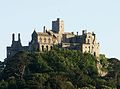
The Castle.
-
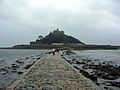
The causeway at low tide.
-
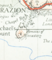
A map from 1946
-
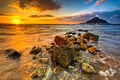
Sunrise over Mount's Bay


