Socotra
Background Information
SOS Children made this Wikipedia selection alongside other schools resources. Click here to find out about child sponsorship.
| Native name: Suquṭra سُقُطْرَى | |
|---|---|
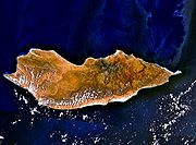
 Landsatview over Socotra 12°29′20.97″N 53°54′25.73″E |
|
 |
|
| Geography | |
| Location | Indian Ocean |
| Coordinates | 12°29′20.97″N 53°54′25.73″E Coordinates: 12°29′20.97″N 53°54′25.73″E |
| Archipelago | Socotra islands |
| Total islands | 4 |
| Major islands | Socotra, Abd al Kuri, Samhah, Darsah |
| Area | 3,796 km2 (1,466 sq mi) |
| Highest elevation | 1,503 m (4,931 ft) |
| Highest point | unnamed point in the Haghier Mountains |
| Country | |
|
Yemen
|
|
| Governorate | Hadhramaut Governorate (حضرموت) |
| Districts | Hidaybū (east) Qulensya Wa Abd Al Kuri (west) |
| Largest city | H̨adībū (pop. 8,545) |
| Demographics | |
| Population | 42,842 (as of 2004 census) |
| Density | 11.3 |
| Ethnic groups | predominantly Arab; but also Afro-Arab, South Asian, Somali and European |
| Socotra Archipelago | |
|---|---|
| Name as inscribed on the World Heritage List | |
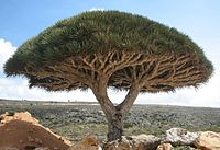
 Tree of genus Dracaena cinnabari |
|
| Country | |
| Type | Natural |
| Criteria | x |
| Reference | 1263 |
| UNESCO region | Arab States |
| Inscription history | |
| Inscription | 2008 (32nd Session) |
Socotra or Soqotra (Arabic سُقُطْرَى ; Suquṭra) is a small archipelago of four islands in the Indian Ocean. The largest island, also called Socotra, is about 95% of the landmass of the archipelago. It lies off some 240 kilometres (150 mi) east of the Horn of Africa and 380 kilometres (240 mi) south of the Arabian Peninsula. The island is very isolated and through the process of speciation, a third of its plant life is found nowhere else on the planet. It has been described as the most alien-looking place on Earth.
Socotra is part of the Republic of Yemen. It has long been a part of the 'Adan Governorate, but in 2004 it became attached to the Hadhramaut Governorate, which is much closer to the island than 'Adan (although the closest governorate would be Al Mahrah).
History
There was initially an Oldoway (or Oldowan) culture in Socotra. Oldoway stone tools were found in the area around Hadibo by V.A. Zhukov, a member of the Russian Complex Expedition in 2008.
Socotra appears as Dioskouridou ("of the Dioscurides") in the Periplus of the Erythraean Sea, a 1st century A.D. Greek navigation aid. In the notes to his translation of the Periplus, G.W.B. Huntingford remarks that the name Socotra is not Greek in origin, but derives from the Sanskrit dvipa sukhadhara ("island of bliss").
A local tradition holds that the inhabitants were converted to Christianity by Thomas in AD 52. In the 10th century, the Arab geographer Abu Mohammed Al-Hassan Al-Hamdani stated that in his time most of the inhabitants were Christians. Socotra is also mentioned in The Travels of Marco Polo according to which "the inhabitants are baptised Christians and have an "archbishop"" who, it is further explained, "has nothing to do with the Pope in Rome, but is subject to an archbishop who lives at Baghdad". They were Nestorians but they also practiced ancient magic rituals despite the warnings of their archbishop.
In 1507, a fleet commanded by Tristão da Cunha with Afonso de Albuquerque landed an occupying force at the then capital of Suq, their objective was a Portuguese base to stop Arab commerce from the Red Sea to the Indian Ocean, and to liberate the presumed friendly Christians from Islamic rule. Here they started to build a fortress. However, they were not welcomed as enthusiastically as they had expected and abandoned the island four years later. The island was also come across by Somali sailors.
The islands passed under the control of the Mahra sultans in 1511. Later, in 1886 it became a British protectorate, along with the remainder of the Mahra State of Qishn and Socotra. For the British it was an important strategic stop-over. The P&O ship Aden sank after being wrecked on a reef near Socotra, in 1897, with the loss of 78 lives.
In October 1967, the Mahra sultanate was abolished. On 30 November 1967, Socotra became part of the People's Republic of South Yemen (later to become the People's Democratic Republic of Yemen). Today it is part of the Republic of Yemen.
Geography and climate
Socotra is one of the most isolated landforms on Earth of continental origin (i.e. not of volcanic origin). The archipelago was once part of the supercontinent of Gondwana and detached during the Miocene, in the same set of rifting events that opened the Gulf of Aden to its northwest.
The archipelago consists of the main island of Socotra (3,625 km2 (1,400 sq mi)), the three smaller islands of Abd al Kuri, Samhah and Darsa and small rock outcrops like Ka’l Fir’awn and Sābūnīyah that are uninhabitable by humans but important for seabirds.
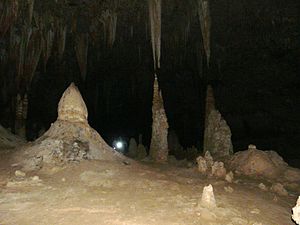
The main island has three geographical terrains: the narrow coastal plains, a limestone plateau permeated with karstic caves and the Haghier Mountains. The mountains rise to 5,000 feet (1,500 metres). The island is a little over 80 miles (130 kilometres) long east to west and typically 18–22 miles (29–35 kilometres) north to south.
The climate for Socotra is classified in the Köppen climate classification as BWh, meaning dry desert with a mean annual temperature over 18°C (64°F). Yearly rainfall is light, and tends to occur during the Northern Hemisphere winter. Generally the higher inland areas receive more rain than the coastal lowlands, due to orographic lift provided by the interior mountains. The monsoon season brings strong winds and high seas.
Flora and fauna
Socotra is considered the jewel of biodiversity in the Arabian Sea. The long geological isolation of the Socotra archipelago and its fierce heat and drought have combined to create a unique and spectacular endemic flora. Surveys have revealed that more than a third of the 800 or so plant species of Socotra are found nowhere else. Botanists rank the flora of Socotra among the ten most endangered island flora in the world. The archipelago is a site of global importance for biodiversity conservation and a possible centre for ecotourism.
One of the most striking of Socotra's plants is the dragon's blood tree ( Dracaena cinnabari), which is a strange-looking, umbrella-shaped tree. Its red sap was the dragon's blood of the ancients, sought after as a medicine and a dye, and today used as paint and varnish. Also important in ancient times were Socotra's various endemic aloes, used medicinally, and for cosmetics. Other endemic plants include the giant succulent tree Dorstenia gigas, the cucumber tree Dendrosicyos, and the rare Socotran pomegranate, Punica protopunica.
The island group also has a rich bird fauna, including a few types of endemic birds, such as the Socotra Starling Onychognathus frater, the Socotra Sunbird Nectarinia balfouri, Socotra Sparrow Passer insularis and Socotra Grosbeak Rhynchostruthus socotranus, many endangered by non-native feral cats. There is even an endemic monotypic genus of birds, the Socotra Warbler Incana incana.
As with many isolated island systems, bats are the only mammals native to Socotra. In contrast, the coral reefs of Socotra are diverse, with many endemic species. There is concern that introduced species, such as goats, may present a threat to the native flora of Socotra in the future.
UNESCO recognition
The island was recognised by the United Nations Educational, Scientific and Cultural Organization (UNESCO) as a world natural heritage site in July 2008. The European Union has supported such a move, calling on both UNESCO and International Organisation of Protecting Environment to classify the island archipelago among the environmental heritages. Sabanet, 2008-04-15.
People and economy
The inhabitants are of Arab, Somali and South Asian origins. They follow the Islamic faith, and speak Soqotri, a Semitic language. Their primary occupation has been fishing, livestock rearing and date cultivation. Almost all inhabitants of Socotra, numbered at 50,000, live on the main island. The principal city is Hadiboh (population 8,545 at the census of 2004). The second largest town is Qulansiyah, with a population of 3,862, followed by Qād̨ub, population 929. Those three main towns are all located on the north coast. 'Abd-al-Kūrī and Samha have a population of a few hundred people between them; Darsa and the remaining islands are uninhabited.
The archipelago forms two districts of the Hadhramaut Governorate:
- Hadībū (حديبو), capital H̨adībū, consisting of about the eastern two thirds of the main island of Socotra, with a population of 32,285
- Qulansiyah wa 'Abd-al-Kūrī (قلنسيه وعبد الكوري), capital Qulansiyah, consisting of the western third of the main island, and the minor islands, specifically 'Abd-al-Kūrī, with a population of 10,557
Traditionally, the archipelago has been inaccessible from June to September due to monsoon weather. However, in July 1999 a new airport opened up Socotra to the outside world all year round, with both Yemen Airways and Felix Airways providing flights once a week to Aden and everyday to Sanaa. All flights have a stop in Riyan-Mukalla Airport, RIY. Socotra Island Airport is located about 12 km west of the main city, H̨adībū, and close to the third largest city, Qād̨ub. Its ICAO code is OYSQ. Electricity is widely available in Socotra with installations of diesel generators, but in Hadiboh there is no electricity from 5am until 9am daily. There are two excellent paved roads: one along the north shore from Quelensiyah to Hadiboh and then to DiHamri area, and another from the north coast to the south coast through the Dixsam Plateau. Public transport is limited in Socotra, taxis are available only as a kind of rent-a-car service of 4WD vehicle with a driver. The former capital is located to the east of Hadiboh. On the western end of Hadiboh lies a small Yemeni Army barracks. The President of Yemen, Ali Abdullah Saleh, has a residence there as well.
The Semitic language Soqotri spoken originally only in Socotra, is related to other Modern South Arabian languages on the Arabian mainland such as Mehri, Harsusi, Bathari, Shehri and Hobyot. It is also spoken by the Soqotri minorities in the United Arab Emirates and other Gulf states.
Some residents raise cattle and goats. The chief export products of the island are dates, ghee, tobacco and fish.
At the end of the 1990s, a United Nations Development Program was launched with the aim of providing a close survey of the island of Socotra.
The majority of male residents on Socotra are reported on Wikipedia to be in the J* subclade of Y-DNA haplogroup J. Several of the female lineages on the island, notably those in mtDNA haplogroup N, are found nowhere else on earth.
Transport
Public transport on Socotra is limited to infrequent minibuses to Qalansiya and to the villages on northeastern coast, car hire usually means hiring a 4WD car with driver.
Ships connect the only Socotra port - 5 km east of Hadibu with Yemeni coastal city of Mukalla (Al-Mukalla). According to information from the ports of Mukalla and Hadibu the journey takes 2–3 days and the service is used mostly for cargo.
Yemenia and Felix Airways fly from Socotra Airport to Sanaa and Aden via Mukalla (RIY - Riyan Airport). The Sanaa service is everyday, while Aden flights are available on Mondays (as of December 2009).
The minibus connecting the airport with Hadibu costs 50 Yemeni riyals. Local drivers often try to charge foreigners more for the route.


