
Latitude
Background to the schools Wikipedia
SOS Children produced this website for schools as well as this video website about Africa. Sponsoring children helps children in the developing world to learn too.
 |
|||||||||||||
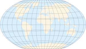
| Map of Earth | |||||||||||||
| Longitude (λ) | |||||||||||||
|---|---|---|---|---|---|---|---|---|---|---|---|---|---|
| Lines of longitude appear vertical with varying curvature in this projection, but are actually halves of great ellipses, with identical radii at a given latitude. | |||||||||||||
| Latitude (φ) | |||||||||||||
| Lines of latitude appear horizontal with varying curvature in this projection; but are actually circular with different radii. All locations with a given latitude are collectively referred to as a circle of latitude. | |||||||||||||
| The equator divides the planet into a Northern Hemisphere and a Southern Hemisphere, and has a latitude of 0°. | |||||||||||||
|
|||||||||||||
Latitude, usually denoted symbolically by the Greek letter phi,  , gives the location of a place on Earth (or other planetary body) north or south of the equator. Lines of Latitude are the horizontal lines shown running east-to-west on maps. Technically, latitude is an angular measurement in degrees (marked with °) ranging from 0° at the Equator (low latitude) to 90° at the poles (90° N for the North Pole or 90° S for the South Pole; high latitude). The complementary angle of a latitude is called the colatitude.
Circles of latitude
All locations of a given latitude are collectively referred to as a circle of latitude or line of latitude or parallel, because they are coplanar, and all such planes are parallel to the equator. Lines of latitude other than the Equator are approximately small circles on the surface of the Earth; they are not geodesics since the shortest route between two points at the same latitude involves moving farther away from, then towards, the equator (see great circle).

A specific latitude may then be combined with a specific longitude to give a precise position on the Earth's surface (see satellite navigation system).
Important named circles of latitude
Besides the equator, four other lines of latitude are named because of the role they play in the geometrical relationship with the Earth and the Sun:
- Arctic Circle — 66° 33′ 39″ N
- Tropic of Cancer — 23° 26′ 21″ N
- Tropic of Capricorn — 23° 26′ 21″ S
- Antarctic Circle — 66° 33′ 39″ S
Only at latitudes between the Tropics is it possible for the sun to be at the zenith. Only north of the Arctic Circle or south of the Antarctic Circle is the midnight sun possible.
The reason that these lines have the values that they do, lies in the axial tilt of the Earth with respect to the sun, which is 23° 26′ 21.41″.
Note that the Arctic Circle and Tropic of Cancer and the Antarctic Circle and Tropic of Capricorn are colatitudes since the sum of their angles is 90°.
Subdivisions
To simplify calculations where elliptical consideration is not important, the nautical mile was created, equaling exactly 111.12 km per degree of arc or, sub-dividing into minutes, 1852 metres per minute of arc. One minute of latitude can be further divided into 60 seconds. A latitude is thus specified as 13°19'43″ N (for greater precision, a decimal fraction can be added to the seconds). An alternative representation uses only degrees and minutes, where the seconds are expressed as a decimal fraction of minutes, thus the above example is expressed as 13°19.717' N. Degrees can also be expressed singularly, with both the minutes and seconds incorporated as a decimal number and rounded as desired (decimal degree notation): 13.32861° N. Sometimes, the north/south suffix is replaced by a negative sign for south (−90° for the South Pole).
Effect of latitude

A region's latitude has a great effect on its climate and weather (see Effect of sun angle on climate). Latitude more loosely determines tendencies in polar auroras, prevailing winds, and other physical characteristics of geographic locations.
Researchers at Harvard's Centre for International Development (CID) found in 2001 that only three tropical economies — Hong Kong, Singapore, and Taiwan — were classified as high-income by the World Bank, while all countries within regions zoned as temperate had either middle- or high-income economies.
Elliptic parameters
Because most planets (including Earth) are ellipsoids of revolution, or spheroids, rather than spheres, both the radius and the length of arc varies with latitude. This variation requires the introduction of elliptic parameters based on an ellipse's angular eccentricity,  (which equals
  , where
  and
and  are the equatorial and polar radii;
  is the first eccentricity squared,
  ; and
; and  or
or  is the flattening,
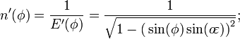
  ). Utilized in creating the integrands for curvature is the inverse of the principal elliptic integrand,
  :
:
Degree length
The length of an arcdegree of latitude (north-south) is about 60 nautical miles, 111 kilometres or 69 statute miles at any latitude. The length of an arcdegree of longitude (east-west) at the equator is about the same, reducing to zero at the poles.
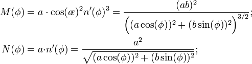
In the case of a spheroid, a meridian and its anti-meridian form an ellipse, from which an exact expression for the length of an arcdegree of latitude is:

This radius of arc (or "arcradius") is in the plane of a meridian, and is known as the meridional radius of curvature,  .
.
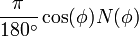
Similarly, an exact expression for the length of an arcdegree of longitude is:
The arcradius contained here is in the plane of the prime vertical, the east-west plane perpendicular (or " normal") to both the plane of the meridian and the plane tangent to the surface of the ellipsoid, and is known as the normal radius of curvature,  .
.
Along the equator (east-west), equals the equatorial radius. The radius of curvature at a right angle to the equator (north-south), , is 43 km shorter, hence the length of an arcdegree of latitude at the equator is about 1 km less than the length of an arcdegree of longitude at the equator. The radii of curvature are equal at the poles where they are about 64 km greater than the north-south equatorial radius of curvature because the polar radius is 21 km less than the equatorial radius. The shorter polar radii indicate that the northern and southern hemispheres are flatter, making their radii of curvature longer. This flattening also 'pinches' the north-south equatorial radius of curvature, making it 43 km less than the equatorial radius. Both radii of curvature are perpendicular to the plane tangent to the surface of the ellipsoid at all latitudes, directed toward a point on the polar axis in the opposite hemisphere (except at the equator where both point toward Earth's centre). The east-west radius of curvature reaches the axis, whereas the north-south radius of curvature is shorter at all latitudes except the poles.
The WGS84 ellipsoid, used by all GPS devices, uses an equatorial radius of 6378137.0 m and an inverse flattening, (1/f), of 298.257223563, hence its polar radius is 6356752.3142 m and its first eccentricity squared is 0.00669437999014. The more recent but little used IERS 2003 ellipsoid provides equatorial and polar radii of 6378136.6 and 6356751.9 m, respectively, and an inverse flattening of 298.25642. Lengths of degrees on the WGS84 and IERS 2003 ellipsoids are the same when rounded to six significant digits. An appropriate calculator for any latitude is provided by the U.S. government's National Geospatial-Intelligence Agency (NGA).
| Latitude | N-S radius of curvature, |
Degree of latitude |
E-W radius of curvature, |
Degree of longitude |
|
|---|---|---|---|---|---|
| 0° | 6335.44 km | 110.574 km | 6378.14 km | 111.320 km | |
| 15° | 6339.70 km | 110.649 km | 6379.57 km | 107.551 km | |
| 30° | 6351.38 km | 110.852 km | 6383.48 km | 96.486 km | |
| 45° | 6367.38 km | 111.132 km | 6388.84 km | 78.847 km | |
| 60° | 6383.45 km | 111.412 km | 6394.21 km | 55.800 km | |
| 75° | 6395.26 km | 111.618 km | 6398.15 km | 28.902 km | |
| 90° | 6399.59 km | 111.694 km | 6399.59 km | 0.000 km |
Types of latitude
With a spheroid that is slightly flattened by its rotation, cartographers refer to a variety of auxiliary latitudes to precisely adapt spherical projections according to their purpose.
For planets other than Earth, such as Mars, geographic and geocentric latitude are called "planetographic" and "planetocentric" latitude, respectively. Most maps of Mars since 2002 use planetocentric coordinates.
Common "latitude"
- In common usage, "latitude" refers to geodetic or geographic latitude and is the angle between the equatorial plane and a line that is normal to the reference spheroid, which approximates the shape of Earth to account for flattening of the poles and bulging of the equator.
The expressions following assume elliptical polar sections and that all sections parallel to the equatorial plane are circular. Geographic latitude (with longitude) then provides a Gauss map.
Reduced latitude
- Reduced or parametric latitude,
 , is the latitude of the same radius on the sphere with the same equator.
Authalic latitude
- Authalic latitude,
 , gives an area-preserving transform to the sphere.
Rectifying latitude
- Rectifying latitude,
 , is the surface distance from the equator, scaled so the pole is 90°, but involves elliptic integration:
Conformal latitude
- Conformal latitude,
 , gives an angle-preserving ( conformal) transform to the sphere.
Geocentric latitude
- The geocentric latitude,
 , is the angle between the equatorial plane and a line from the centre of Earth.
Comparison of latitudes
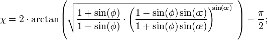
The following plot shows the differences between the types of latitude. The data used is found in the table following the plot. Please note that the values in the table are in minutes, not degrees, and the plot reflects this as well. Also note that the conformal symbols are hidden behind the geocentric due to being very close in value.

-
Approximate difference from geographic latitude ("Lat") Lat Reduced 
Authalic 
Rectifying 
Conformal 
Geocentric 
0° 0.00′ 0.00′ 0.00′ 0.00′ 0.00′ 5° 1.01′ 1.35′ 1.52′ 2.02′ 2.02′ 10° 1.99′ 2.66′ 2.99′ 3.98′ 3.98′ 15° 2.91′ 3.89′ 4.37′ 5.82′ 5.82′ 20° 3.75′ 5.00′ 5.62′ 7.48′ 7.48′ 25° 4.47′ 5.96′ 6.70′ 8.92′ 8.92′ 30° 5.05′ 6.73′ 7.57′ 10.09′ 10.09′ 35° 5.48′ 7.31′ 8.22′ 10.95′ 10.96′ 40° 5.75′ 7.66′ 8.62′ 11.48′ 11.49′ 45° 5.84′ 7.78′ 8.76′ 11.67′ 11.67′ 50° 5.75′ 7.67′ 8.63′ 11.50′ 11.50′ 55° 5.49′ 7.32′ 8.23′ 10.97′ 10.98′ 60° 5.06′ 6.75′ 7.59′ 10.12′ 10.13′ 65° 4.48′ 5.97′ 6.72′ 8.95′ 8.96′ 70° 3.76′ 5.01′ 5.64′ 7.52′ 7.52′ 75° 2.92′ 3.90′ 4.39′ 5.85′ 5.85′ 80° 2.00′ 2.67′ 3.00′ 4.00′ 4.01′ 85° 1.02′ 1.35′ 1.52′ 2.03′ 2.03′ 90° 0.00′ 0.00′ 0.00′ 0.00′ 0.00′
Astronomical latitude
A more obscure measure of latitude is the astronomical latitude, which is the angle between the equatorial plane and the normal to the geoid (ie a plumb line). It originated as the angle between horizon and pole star.
Astronomical latitude is not to be confused with declination, the coordinate astronomers use to describe the locations of stars north/south of the celestial equator (see equatorial coordinates), nor with ecliptic latitude, the coordinate that astronomers use to describe the locations of stars north/south of the ecliptic (see ecliptic coordinates).
Palæolatitude
Continents move over time, due to continental drift, taking whatever fossils and other features of interest they may have with them. Particularly when discussing fossils, it's often more useful to know where the fossil was when it was laid down, than where it is when it was dug up: this is called the palæolatitude of the fossil. The Palæolatitude can be constrained by palæomagnetic data. If tiny magnetisable grains are present when the rock is being formed, these will align themselves with Earth's magnetic field like compass needles. A magnetometer can deduce the orientation of these grains by subjecting a sample to a magnetic field, and the magnetic declination of the grains can be used to infer the latitude of deposition.
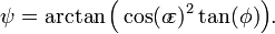
Corrections for altitude

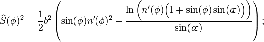
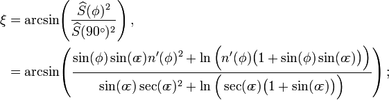
When converting from geodetic ("common") latitude, corrections must be made for altitude for systems which do not measure the angle from the normal of the spheroid. In the figure at right, point H (located on the surface of the spheroid) and point H' (located at some greater elevation) have different geocentric latitudes (angles β and γ respectively), even though they share the same geodetic latitude (angle α). (Note that the flatness of the spheroid and elevation of point H' is significantly greater than what is found on the Earth, exaggerating the errors commonly found in such calculations.)