 |
This is a file from the Wikimedia Commons. Information from its description page there is shown below.
Commons is a freely licensed media file repository. You can help.
|
Summary
| Description |
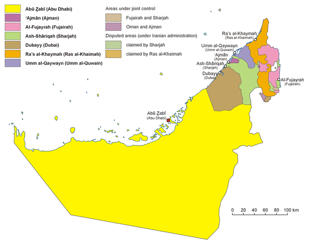
English: Administrative map of the United Arab Emirates in English
Français : Carte des divisions administratives des Emirats arabes unis en Anglais
Hrvatski: Politički zemljovid Ujedinjenih Arapskih Emirata, inačica na engleskom
Polski: Mapa administracyjna Zjednoczonych Emiratów Arabskich, wersja anglojęzyczna
日本語: アラブ首長国連邦の行政区分図(英語版)
|
| Date |
5 January 2007 |
| Source |
Own work, based on map of the United Arab Emirates published in Wielki Encyklopedyczny Atlas Świata (The Great Encyclopedian World Atlas), vol. 10 Azja Południowo-Zachodnia (Southwest Asia), Polish Scientific Publishers PWN, Warsaw 2006, p. 76-78 |
| Author |
Aotearoa |
Licensing
I, the copyright holder of this work, hereby publish it under the following license:
 |
Permission is granted to copy, distribute and/or modify this document under the terms of the GNU Free Documentation License, Version 1.2 or any later version published by the Free Software Foundation; with no Invariant Sections, no Front-Cover Texts, and no Back-Cover Texts. A copy of the license is included in the section entitled GNU Free Documentation License. http://www.gnu.org/copyleft/fdl.htmlGFDLGNU Free Documentation Licensetruetrue
|
|
File usage
The following pages on Schools Wikipedia link to this image (list may be incomplete):
This file contains additional information, probably added from the digital camera or scanner used to create or digitize it. If the file has been modified from its original state, some details may not fully reflect the modified file.
All five editions of Schools Wikipedia were compiled by SOS Childrens Villages. SOS Children's Villages helps more than 2 million people across 133 countries around the world. Try to find out how you can help children in other countries on our web site.


