
File:VietnameseProvincesMap.png
| |
This is a file from the Wikimedia Commons. Information from its description page there is shown below.
Commons is a freely licensed media file repository. You can help. |
 |
This map image could be recreated using vector graphics as an SVG file. This has several advantages; see Commons:Media for cleanup for more information. If an SVG form of this image is already available, please upload it. After uploading an SVG, replace this template with {{ vector version available|new image name.svg}}. |
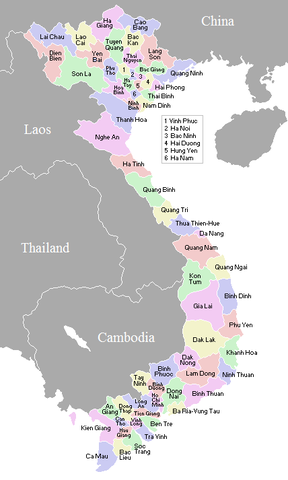
Original at: w:Image:VietnameseProvincesMap.png, where it says:
A map showing the borders and names of the Vietnamese provinces (including the changes approved in Nov 2003)
This country locator map was created by Vardion and is released into the public domain.
So this map is up to date as per current situation Waerth 07:19, 17 Mar 2005 (UTC)
See vi:Image:VietnameseProvincesMapTiengViet.png for the same map with the correctly accented Vietnamese names.
 |
This work has been released into the public domain by its author, Waerth. This applies worldwide. In some countries this may not be legally possible; if so: Waerth grants anyone the right to use this work for any purpose, without any conditions, unless such conditions are required by law.
|
File usage
Background information
Wikipedia for Schools brings Wikipedia into the classroom. More than 2 million people benefit from the global charity work of SOS Children, and our work in 133 countries around the world is vital to ensuring a better future for vulnerable children. Have you heard about child sponsorship? Visit our web site to find out.