 |
This is a file from the Wikimedia Commons. Information from its description page there is shown below.
Commons is a freely licensed media file repository. You can help.
|
 |
This map image could be recreated using vector graphics as an SVG file. This has several advantages; see Commons:Media for cleanup for more information. If an SVG form of this image is already available, please upload it. After uploading an SVG, replace this template with {{ vector version available|new image name.svg}}. |
| DescriptionVietnam Expand1.gif |
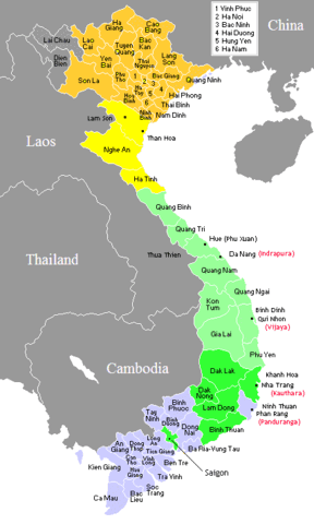
English: Provinces map of Vietnam
900 AD
1100 AD
1475 AD
1650 AD
1760 AD
Français : Carte des provinces du Viêt Nam
|
| Date |
7 December 2006 |
| Source |
English: own work - based on province map of Vietnam. Map dates based on "The Empire of Le Thanh-tong" (from Jonh Whitmore's "The Development of Le Government"; and map found in "Les frontieres du Vietnam"; P.B. Lafont, Edition l’Harmattan, Paris 1989; and maps found in DK Atlas of World History.
|
| Author |
English: Created by CGlassey and uploaded by Electionworld
|
I, the copyright holder of this work, hereby publish it under the following licenses:
 |
Permission is granted to copy, distribute and/or modify this document under the terms of the GNU Free Documentation License, Version 1.2 or any later version published by the Free Software Foundation; with no Invariant Sections, no Front-Cover Texts, and no Back-Cover Texts. A copy of the license is included in the section entitled GNU Free Documentation License. http://www.gnu.org/copyleft/fdl.htmlGFDLGNU Free Documentation Licensetruetrue
|

 |
This file is licensed under the Creative Commons Attribution 2.5 Generic license. |
|
|
|
- You are free:
- to share – to copy, distribute and transmit the work
- to remix – to adapt the work
- Under the following conditions:
- attribution – You must attribute the work in the manner specified by the author or licensor (but not in any way that suggests that they endorse you or your use of the work).
http://creativecommons.org/licenses/by/2.5 CC-BY-2.5 Creative Commons Attribution 2.5 truetrue
|
You may select the license of your choice.
|
File usage
The following pages on Schools Wikipedia link to this image (list may be incomplete):
SOS Childrens Villages has brought Wikipedia to the classroom. The world's largest orphan charity, SOS Children's Villages brings a better life to more than 2 million people in 133 countries around the globe. There are many ways to help with SOS Childrens Villages.


