
File:Kosovo map-en.svg
| |
This is a file from the Wikimedia Commons. Information from its description page there is shown below.
Commons is a freely licensed media file repository. You can help. |
|
Summary
| Description |
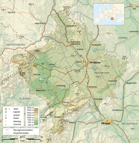
Česky: Mapa Kosova.
Dansk: Kort over Kosovo.
Deutsch: Karte des Kosovo.
English: Map of the Kosovo.
Español: Mapa de Kosovo.
Français: Carte du Kosovo, en anglais.
Magyar: Koszovó térképe albán és szerb helységnevekkel.
Italiano: Mappa del Kosovo.
Polski: Mapa Kosowa.
Română: Harta provinciei Kosovo
Svenska: Karta över Kosovo, engelskspråkig.
Türkçe: Kosova haritası.
Русский: Карта Косово, на английском.
日本語: コソボの地図。
|
| Date | 26 February 2008 |
| Source | Own work. Sources :
Software used :
Other data :
|
| Author | Sémhur |
|
Camera location |
|
View this and other nearby images on: Google Maps - Google Earth - OpenStreetMap | ( Info) |
|---|
This map was improved or created by the Wikigraphists of the Graphic Lab (fr). You can propose images to clean up, improve, create or translate as well.
বাংলা | català | česky | Deutsch | Deutsch (Sie-Form) | Ελληνικά | English | Esperanto | español | suomi | français | עברית | magyar | Հայերեն | italiano | 한국어 | македонски | Bahasa Melayu | Plattdüütsch | Nederlands | occitan | polski | português | română | русский | slovenščina | svenska | татарча/tatarça | Türkçe | українська | 中文 | 中文(简体) | 中文(繁體) | Zazaki | +/−
| |
This SVG file uses embedded text that can be easily translated into your language using this automated tool. Learn more. You can also download it and translate it manually using a text editor.
|
|
|
This vector image was created with Inkscape. |
Licensing
|

| Annotations | This image is annotated: View the annotations at Commons |
File usage
Metadata
A background to Schools Wikipedia
SOS Children's Villages has brought Wikipedia to the classroom. In 133 nations around the world, SOS Childrens Villages works to bring better education and healthcare to families in desperate need of support. Help another child by taking out a sponsorship.