
File:Cocos (Keeling) Islands-CIA WFB Map.png
Cocos_(Keeling)_Islands-CIA_WFB_Map.png (329 × 355 pixels, file size: 5 KB, MIME type: image/png)
| |
This is a file from the Wikimedia Commons. Information from its description page there is shown below.
Commons is a freely licensed media file repository. You can help. |
| Description |
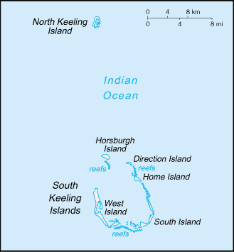
Русский: Карта Кокосовых (Килинг) островов
|
|||
| Date | ||||
| Source | https://www.cia.gov/library/publications/the-world-factbook/maps/ck-map.gif | |||
| Author | CIA World Factbook | |||
| Permission ( Reusing this file) |
|


File usage
The following pages on Schools Wikipedia link to this image (list may be incomplete):
Find out more
Schools Wikipedia has made the best of Wikipedia available to students. By supporting vulnerable children right through to adulthood, SOS Children makes a lasting difference to the lives of thousands of people. Education is a key part of our work, and our schools provide high-quality teaching to the children in our care. There are many ways to help with SOS Childrens Villages.