
File:Map Norway political-geo.png
Size of this preview: 317 × 479 pixels.
| |
This is a file from the Wikimedia Commons. Information from its description page there is shown below.
Commons is a freely licensed media file repository. You can help. |
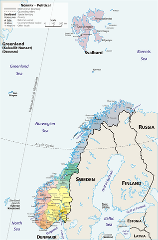
Summary
Map: Norway – geopolitical
Exhibits counties (fylker) of Norway (19); colours correspond to regions of Norway:
- yellow: Østlandet (Austlandet)
- orange: Sørlandet
- red: Vestlandet
- green: Trøndelag
- blue: Nord-Norge
Also:
- violet: Svalbard; Jan Mayen
Drawn by E Pluribus Anthony, adapted from:
Licensing
 |
This work has been released into the public domain by its author, E Pluribus Anthony. This applies worldwide. In some countries this may not be legally possible; if so: E Pluribus Anthony grants anyone the right to use this work for any purpose, without any conditions, unless such conditions are required by law.
|
Link: http://en.wikipedia.org/wiki/Image:Map_Norway_political-geo.png
derivative works
Derivative works of this file:
File usage
The following pages on Schools Wikipedia link to this image (list may be incomplete):
Find out about Schools Wikipedia
Wikipedia for Schools was collected by SOS Children's Villages. SOS Childrens Villages is an international children's charity, providing a good home and loving family to thousands of children who have lost their parents. We also work with communities to help vulnerable families stay together and raise children in the best possible environment. Why not try to find out more about sponsoring a child?