
File:Mapmaunaloa.png
Mapmaunaloa.png (279 × 299 pixels, file size: 4 KB, MIME type: image/png)
| |
This is a file from the Wikimedia Commons. Information from its description page there is shown below.
Commons is a freely licensed media file repository. You can help. |
 |
File:Mapmaunaloa.svg is a vector version of this file. It should be used in place of this raster image when superior. File:Mapmaunaloa.png
For more information about vector graphics, read about Commons transition to SVG.
|
 |
| Description |
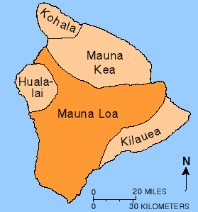
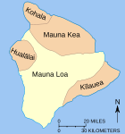
English: Map showing relationship of Mauna Loa to other volcanoes that form the Big Island of Hawaii
|
| Date | - |
| Source | http://hvo.wr.usgs.gov/maunaloa/ |
| Author | Hawaii Volcano Observatory, USGS |
| Permission ( Reusing this file) |
Public Domain U.S. Government work |
 |
This image is in the public domain because it contains materials that originally came from the United States Geological Survey, an agency of the United States Department of the Interior. For more information, see the official USGS copyright policy. български | català | Deutsch | English | español | eesti | suomi | français | galego | italiano | 한국어 | македонски | മലയാളം | Nederlands | polski | português | русский | Türkçe | 中文 | 中文(简体) | +/− |
|
File usage
The following pages on Schools Wikipedia link to this image (list may be incomplete):
What is Schools Wikipedia?
SOS Childrens Villages chose the best bits of Wikipedia to help you learn. Thanks to SOS Children, 62,000 children are enjoying a happy childhood, with a healthy, prosperous future ahead of them. Sponsoring a child is a great way to help children who need your support.