 |
This is a file from the Wikimedia Commons. Information from its description page there is shown below.
Commons is a freely licensed media file repository. You can help.
|
 |
The factual accuracy of this diagram is disputed The dispute is about: Names "Éire" and "Republic of Ireland" are problematic. See w:en:Names of the Irish state Please discuss the issue on this diagram's talk page. For usage see: {{ disputed diagram|why|…}}
|
| Description |
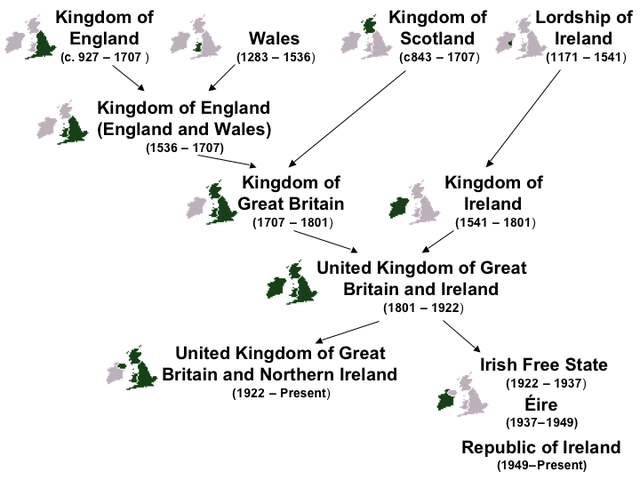
English: New PNG version of :Image:Nations of the UK.jpg. Created by JW1805 using MS Powerpoint.
|
| Date |
29 October 2006 (first version); 20 October 2008 (last version) |
| Source |
Transferred from en.wikipedia |
| Author |
Original uploader was JW1805 at en.wikipedia. Later version(s) were uploaded by Daicaregos at en.wikipedia. |
Permission
( Reusing this file) |
CC-BY-SA-2.5.
|
Licensing
 |
This map image could be recreated using vector graphics as an SVG file. This has several advantages; see Commons:Media for cleanup for more information. If an SVG form of this image is already available, please upload it. After uploading an SVG, replace this template with {{ vector version available|new image name.svg}}. |
{{tlx|...}}
File usage
The following pages on Schools Wikipedia link to this image (list may be incomplete):
Schools Wikipedia was created by children's charity SOS Children's Villages. Thanks to SOS Children, 62,000 children are enjoying a happy childhood, with a healthy, prosperous future ahead of them. We have helped children in Africa for many years - you can help too...


