
File:Paricutin 30 612.jpg
Size of this preview: 320 × 480 pixels.
| |
This is a file from the Wikimedia Commons. Information from its description page there is shown below.
Commons is a freely licensed media file repository. You can help. |
Summary
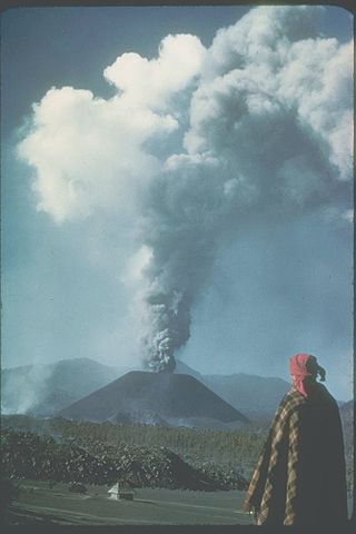
| Description | Paricutin, Mexico;19.48 N 102.25 W;3,170 m elevation This slide shows the cinder cone soon after its birth in 1943 in a Mexican cornfield. During its brief nine-year lifespan (1943-1952), it built a 410-meter-high cone with extensive lava fields around the base of the cone. Most of the 2 km3 of eruptive products (ash, cinders, and lava) were produced in the first few years. Cinder cones such as this one are commonly formed by one eruption. Each subsequent eruption in the same area forms its own cinder cone. |
| Date | 1943 |
| Source | http://www.ngdc.noaa.gov/seg/hazard/slideset/30/30_612_slide.shtml |
| Author | Photo credit: K. Segerstrom, U.S. Geological Survey |
| Permission ( Reusing this file) |
PD-USGov-NOAA |
 |
This image is in the public domain because it contains materials that originally came from the U.S. National Oceanic and Atmospheric Administration, taken or made as part of an employee's official duties.
|
 |
File usage
The following pages on Schools Wikipedia link to this image (list may be incomplete):
Background information
All five editions of Schools Wikipedia were compiled by SOS Children. In 133 nations around the world, SOS Children's Villages works to bring better education and healthcare to families in desperate need of support. Why not try to find out more about sponsoring a child?