
File:Red Sea topographic map-en.jpg
| |
This is a file from the Wikimedia Commons. Information from its description page there is shown below.
Commons is a freely licensed media file repository. You can help. |
Summary
|
Camera location |
|
This and other images at their locations on: Google Maps - Google Earth - OpenStreetMap | ( Info) |
|---|
| Description |
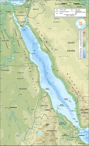
English: Topographic map in English of the Red Sea, UTM projection (WGS84 datum).
Note : for translation purpose, use the SVG version. Français : Carte topographique en anglais de la Mer Rouge, projection UTM (WGS84 datum).
|
||
| Date | April 2008 | ||
| Source | Own work (see complete description on Image:Red_Sea_topographic_map-en.svg) | ||
| Author | Eric Gaba ( Sting - fr:Sting) | ||
| Permission ( Reusing this file) |
|
This map was improved or created by the Wikigraphists of the Graphic Lab (fr). You can propose images to clean up, improve, create or translate as well.
বাংলা | català | česky | Deutsch | Deutsch (Sie-Form) | Ελληνικά | English | Esperanto | español | suomi | français | עברית | magyar | Հայերեն | italiano | 한국어 | македонски | Bahasa Melayu | Plattdüütsch | Nederlands | occitan | polski | português | română | русский | slovenščina | svenska | татарча/tatarça | Türkçe | українська | 中文 | 中文(简体) | 中文(繁體) | Zazaki | +/−
Licensing
|

File usage
Metadata
I want to learn more...
Wikipedia for Schools brings Wikipedia into the classroom. SOS Children's Villages believes education is an important part of a child's life. That's why we ensure they receive nursery care as well as high-quality primary and secondary education. When they leave school, we support the children in our care as they progress to vocational training or higher education. Why not try to find out more about sponsoring a child?