Checked content

File:Waterloo Campaign map-alt3.svg

Wikipedia

Cscr-featured.svgSound-icon-empty.svgThis is a featured picture on the English language Wikipedia ( Featured pictures) and is considered one of the finest images.

If you think this file should be featured on Wikimedia Commons as well, feel free to nominate it.
If you have an image of similar quality that can be published under a suitable copyright license, be sure to upload it, tag it, and nominate it.


Camera location

50° 40′ 49.40″ N, 4° 24′ 42.42″ E

This and other images at their locations on: Google Maps - Google Earth - OpenStreetMap ( Info)
Description
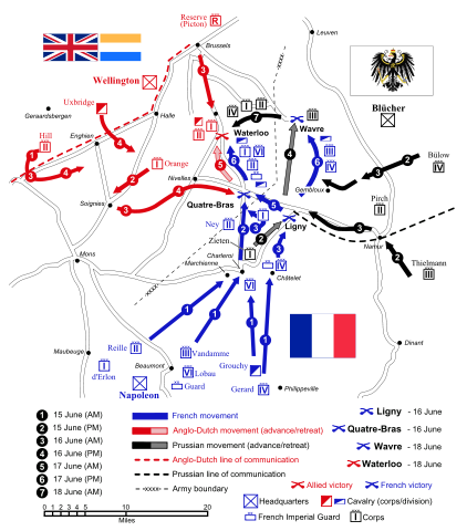
English: Map of force movements and major engagements during the Waterloo Campaign, June 15-18, 1815.


Battles
Commanders
  • France
Commanders (continued)
  • Netherlands
  • Prussia
  • United Kingdom
Inkscape Logo.svg
This vector image was created with Inkscape.
Date 29 December 2007
Source Self-made. Vectorized from raster image Waterloo campaign map.png Flags from Flag of France.svg Flag of the United Kingdom.svg War Ensign of Prussia (1816).svg Prinsenvlag.svg
Author Ipankonin
Permission
( Reusing this file)
I, the copyright holder of this work, hereby publish it under the following licenses:
GNU head Permission is granted to copy, distribute and/or modify this document under the terms of the GNU Free Documentation License, Version 1.2 or any later version published by the Free Software Foundation; with no Invariant Sections, no Front-Cover Texts, and no Back-Cover Texts. A copy of the license is included in the section entitled GNU Free Documentation License.

w:en:Creative Commons
attribution share alike
This file is licensed under the Creative Commons Attribution-Share Alike 3.0 Unported license.
You are free:
  • to share – to copy, distribute and transmit the work
  • to remix – to adapt the work
Under the following conditions:
  • attribution – You must attribute the work in the manner specified by the author or licensor (but not in any way that suggests that they endorse you or your use of the work).
  • share alike – If you alter, transform, or build upon this work, you may distribute the resulting work only under the same or similar license to this one.
This licensing tag was added to this file as part of the GFDL licensing update.

w:en:Creative Commons
attribution share alike
This file is licensed under the Creative Commons Attribution-Share Alike 2.5 Generic, 2.0 Generic and 1.0 Generic license.
You are free:
  • to share – to copy, distribute and transmit the work
  • to remix – to adapt the work
Under the following conditions:
  • attribution – You must attribute the work in the manner specified by the author or licensor (but not in any way that suggests that they endorse you or your use of the work).
  • share alike – If you alter, transform, or build upon this work, you may distribute the resulting work only under the same or similar license to this one.

You may select the license of your choice.

Earth flag PD.jpg

Open this map in Google Earth ( Google Maps, Bing) ( Help| Source)
The following pages on Schools Wikipedia link to this image (list may be incomplete):

Metadata

A background to Schools Wikipedia

Through Schools Wikipedia, SOS Children's Villages has brought learning to children around the world. In 133 nations around the world, SOS Childrens Villages works to bring better education and healthcare to families in desperate need of support. There are many ways to help with SOS Childrens Villages.