
File:Usgs map mercator.svg
| |
This is a file from the Wikimedia Commons. Information from its description page there is shown below.
Commons is a freely licensed media file repository. You can help. |
Summary
| Description |
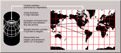
English: Condensed explanation of Mercator-projection maps, converted to SVG format from larger USGS file of GIF format. See enlarged view below, using a wikitable to expand beyond original size.
|
| Date | February 2005 |
| Source | derivative from USGS image file,
|
| Author | derived from US Government USGS |
Enlarged view
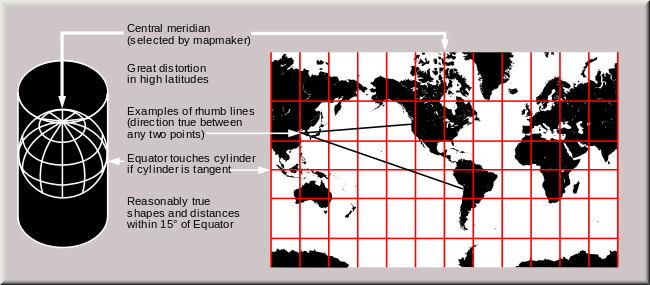 The Mercator projection shows courses of constant bearing as straight lines. While common, scholars advise against using it for reference maps of the world because it drastically inflates the high latitudes. |
Licensing
 |
I, the copyright holder of this work, release this work into the public domain. This applies worldwide. In some countries this may not be legally possible; if so: I grant anyone the right to use this work for any purpose, without any conditions, unless such conditions are required by law.
|
File usage
The following pages on Schools Wikipedia link to this image (list may be incomplete):
Metadata
Learn more about Schools Wikipedia
SOS Children has brought Wikipedia to the classroom. SOS Children cares for children who have lost their parents. Our Children's Villages give these children a new home and a new family, while a high-quality education and the best of medical care ensures they will grow up with all they need to succeed in adult life. Try to find out how you can help children in other countries on our web site.