
File:Keurusselka-WorldWind.jpg
Size of this preview: 331 × 480 pixels.
| |
This is a file from the Wikimedia Commons. Information from its description page there is shown below.
Commons is a freely licensed media file repository. You can help. |
Summary
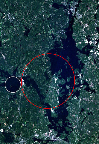
| Description | Landsat 7 satellite image of the Keurusselkä lake region. Keurusselkä impact structure is marked with a red ellipse, suggested impact structure of Ukonselkä is marked with a white circle
|
| Date | 6/5/2006 |
| Source | NASA WorldWind; data based on J. Moilanen's map and the SEIS database |
| Author | NASA |
| Permission ( Reusing this file) |
NASA PD |
Licensing
 |
This image is in the public domain because it is a screenshot from NASA’s globe software World Wind using a public domain layer, such as Blue Marble, MODIS, Landsat, SRTM, USGS or GLOBE.
|
|
File usage
The following pages on Schools Wikipedia link to this image (list may be incomplete):
Metadata
Background information
SOS Childrens Villages chose the best bits of Wikipedia to help you learn. Thanks to SOS Children, 62,000 children are enjoying a happy childhood, with a healthy, prosperous future ahead of them. You can help by sponsoring a child.