
File:Central RER network.gif
| |
This is a file from the Wikimedia Commons. Information from its description page there is shown below.
Commons is a freely licensed media file repository. You can help. |
Summary
| Description |
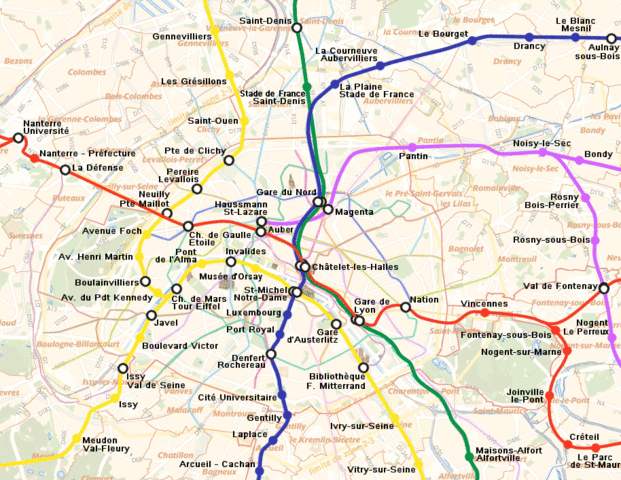
English: Geographically accurate map of the central network of the RER in Paris, France
Deutsch: Lagetreue Karte des RER-Netzes im zentralen Bereich von Paris, Frankreich
Français : Le map de Réseau Express Régional de Paris dans l'aire centrale
|
| Date | December 2005 |
| Source | Own work |
| Author | Metropolitain |
| Permission ( Reusing this file) |
en.wikipedia.org |
 |
This map image could be recreated using vector graphics as an SVG file. This has several advantages; see Commons:Media for cleanup for more information. If an SVG form of this image is already available, please upload it. After uploading an SVG, replace this template with {{ vector version available|new image name.svg}}. |
 |
This image was (or all images in this article or category were) uploaded in the GIF format, while a different format would have been more suitable. Commons discourages the use of GIF files, except for animations. See Commons:File types for more information. If possible, please upload a PNG version (or JPEG for some photos) of this image, and mark the GIF image as {{ superseded|Image:new image name}}. If you like, encourage other Wikimedia projects using the GIF to use the new version instead. If this image is a diagram or other image suitable for vectorisation, please tag this image with {{ convert to SVG}} instead of {{ badGIF}}. If not suitable for vectorisation, use {{ convert to PNG}}. |
Licensing
 |
I, the copyright holder of this work, release this work into the public domain. This applies worldwide. In some countries this may not be legally possible; if so: I grant anyone the right to use this work for any purpose, without any conditions, unless such conditions are required by law.
|
File usage
I want to learn more...
SOS Children has brought Wikipedia to the classroom. SOS Childrens Villages is an international children's charity, providing a good home and loving family to thousands of children who have lost their parents. We also work with communities to help vulnerable families stay together and raise children in the best possible environment. We have helped children in Africa for many years - you can help too...