
File:Portuguese colonial war map1.PNG
Portuguese_colonial_war_map1.PNG (360 × 392 pixels, file size: 12 KB, MIME type: image/png)
| |
This is a file from the Wikimedia Commons. Information from its description page there is shown below.
Commons is a freely licensed media file repository. You can help. |
Contents |
Summary
 |
File:Portuguese colonial war-fr.svg is a vector version of this file. It should be used in place of this raster image when superior. File:Portuguese colonial war map1.PNG
For more information about vector graphics, read about Commons transition to SVG.
|
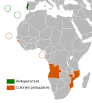 |
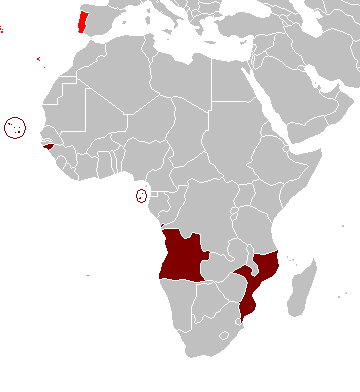
Map of the Portuguese colonies in Africa by the time of the Portuguese Colonial War (1961-1974).
Source
- English Wikipedia, uploaded by User:Mário
Revision history
12:19, 8 April 2006 . . Mário (Talk | contribs) . . 360×392 (12,409 bytes) (Map of the Portuguese colonies in Africa by the time of the Portuguese Colonial War (1961-1974).)
Licensing
 |
I, the copyright holder of this work, release this work into the public domain. This applies worldwide. In some countries this may not be legally possible; if so: I grant anyone the right to use this work for any purpose, without any conditions, unless such conditions are required by law.
|
File usage
The following pages on Schools Wikipedia link to this image (list may be incomplete):
Learn more about Schools Wikipedia
SOS Childrens Villages chose the best bits of Wikipedia to help you learn. The world's largest orphan charity, SOS Childrens Villages brings a better life to more than 2 million people in 133 countries around the globe. Help another child by taking out a sponsorship.