
File:MajorVolcanoesOfThePhilippines-USGS.gif
Size of this preview: 224 × 480 pixels.
| |
This is a file from the Wikimedia Commons. Information from its description page there is shown below.
Commons is a freely licensed media file repository. You can help. |
| Description |
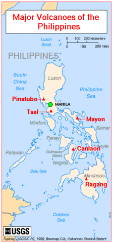
English: Map showing major volcanoes of the Philippines
Français : Carte des principaux volcans aux Philippines
|
| Date | 1999 |
| Source | http://vulcan.wr.usgs.gov/Imgs/Gif/Philippines/Maps/map_philippines_volcanoes.gif on http://vulcan.wr.usgs.gov/Volcanoes/Philippines/Maps/map_philippines_volcanoes.html |
| Author | See bottom edge of the map. |
| Permission ( Reusing this file) |
See [[# Licensing]]. |
Licensing
 |
This image is in the public domain because it contains materials that originally came from the United States Geological Survey, an agency of the United States Department of the Interior. For more information, see the official USGS copyright policy. български | català | Deutsch | English | español | eesti | suomi | français | galego | italiano | 한국어 | македонски | മലയാളം | Nederlands | polski | português | русский | Türkçe | 中文 | 中文(简体) | +/− |
|
File usage
The following pages on Schools Wikipedia link to this image (list may be incomplete):
Find out more
SOS Children's Villages chose the best bits of Wikipedia to help you learn. SOS Childrens Villages works in 133 countries and territories across the globe, helps more than 62,000 children, and reaches over 2 million people in total. Sponsoring a child is the coolest way to help.