
File:River valley filled in by pyroclastic flows, Mt. Pinatubo.jpg
| |
This is a file from the Wikimedia Commons. Information from its description page there is shown below.
Commons is a freely licensed media file repository. You can help. |
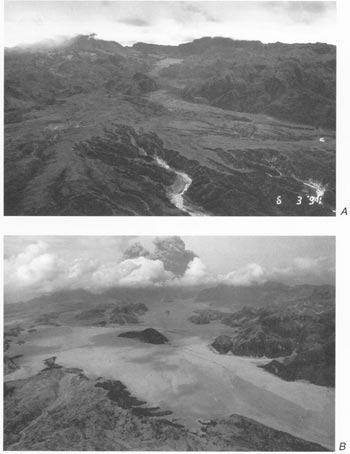
River valley filled in by pyroclastic flows from 1991 eruption of Mt. Pinatubo. Aerial views of Maloma and Marella River valleys comparing preeruption terrain (A) and posteruption terrain with fill of pyroclastic-flow deposits (B). Orientation of both views is northeast toward Mount Pinatubo, but B was taken from a position slightly east of and at higher altitude than that of A. Note hill surrounded by pyroclastic-flow deposits near centre of B and compare with A. Main (east fork) channel of Marella River to east (right) of knob has been filled to a depth of about 200 m.
Source: Fig.2 on
Both photographs by R.P. Hoblitt; A, June 3, 1991; B, June 23, 1991.)
 |
This image is in the public domain because it contains materials that originally came from the United States Geological Survey, an agency of the United States Department of the Interior. For more information, see the official USGS copyright policy. български | català | Deutsch | English | español | eesti | suomi | français | galego | italiano | 한국어 | македонски | മലയാളം | Nederlands | polski | português | русский | Türkçe | 中文 | 中文(简体) | +/− |
|
File usage
Schools Wikipedia facts
Wikipedia for Schools was collected by SOS Children. SOS Children is famous for the love and shelter it brings to lone children, but we also support families in the areas around our Children's Villages, helping those who need us the most. Try to find out how you can help children in other countries on our web site.