
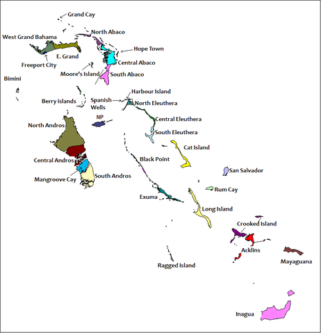
File:Districts of the Bahamas (Labeled).png
Size of this preview: 462 × 479 pixels.
| |
This is a file from the Wikimedia Commons. Information from its description page there is shown below.
Commons is a freely licensed media file repository. You can help. |
| Description |
== Summary == Created by Rarelibra for public domain use. Created using MapInfo Professional v7.5 and referencing various Bahamian map sources. en:Category:Maps of the Bahamas |
| Date | 2010-06-27 19:52 (UTC) |
| Source |
|
| Author |
|
 |
This map image could be recreated using vector graphics as an SVG file. This has several advantages; see Commons:Media for cleanup for more information. If an SVG form of this image is already available, please upload it. After uploading an SVG, replace this template with {{ vector version available|new image name.svg}}. |
| This is a retouched picture, which means that it has been digitally altered from its original version. Modifications: Labells on the various Districts of The Bahamas have been placed.. The original can be viewed here: Districts_of_the_Bahamas.png. Modifications made by Uniongreen113.
|
|

File usage
The following pages on Schools Wikipedia link to this image (list may be incomplete):
A background to Schools Wikipedia
All five editions of Schools Wikipedia were compiled by SOS Children. SOS Children cares for children who have lost their parents. Our Children's Villages give these children a new home and a new family, while a high-quality education and the best of medical care ensures they will grow up with all they need to succeed in adult life. If you'd like to help, why not learn how to sponsor a child?