
File:Radar antenna.jpg
| |
This is a file from the Wikimedia Commons. Information from its description page there is shown below.
Commons is a freely licensed media file repository. You can help. |
Contents |
Summary
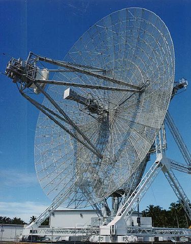
This RADAR is the ARPA Long-Range Tracking and Instrumentation Radar (ALTAIR) located in the Kwajalein atoll on the island of Roi-Namur in the Ronald Reagan Ballistic Missile Defense Test Site. It was initially developed and built between 1968 and 1970.
For full specifications see: http://www.smdc.army.mil/kwaj/rangeinst/altair.html http://www.fas.org/spp/military/program/nssrm/initiatives/altair.htm
Source
http://www.smdc.army.mil/SMDCPhoto_Gallery/Sensors/Radar.jpg from http://www.smdc.army.mil/SMDCPhoto_Gallery/Sensors/Sensors.html
Licensing
2. Information presented on the SMDC home page is considered public information and may be distributed or copied. Use of appropriate byline/photo/image credit is requested. - http://www.smdc.army.mil/SMDC2004/Privacy.html
 |
This image is a work of a U.S. Army soldier or employee, taken or made as part of that person's official duties. As a work of the U.S. federal government, the image is in the public domain.
|
 |
Upload history at other wikipedias
- 05:40, 29 Jul 2004 . . Doritos654 (10203 bytes) (Update Radar Image)
- 03:22, 16 Jul 2004 . . Raul654 (82084 bytes)
File usage
The best way to learn
SOS Children's Villages has brought Wikipedia to the classroom. SOS Children helps those who have nothing and no one, giving them back the famly they have lost and bringing them the very best opportunities for a happy, healthy future. Sponsoring a child is the coolest way to help.