
File:1652 Merian Panoramic View or Map of Rome, Italy - Geographicus - Roma-merian-1642.jpg
| |
This is a file from the Wikimedia Commons. Information from its description page there is shown below.
Commons is a freely licensed media file repository. You can help. |
| Artist | http://www.geographicus.com/mm5/cartographers/merian.txt | |||||
| Title | Roma. | |||||
| Description |
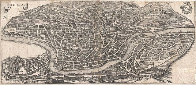
English: An important and stunning c. 1641 bird's eye view and map of Rome by Matthus Merian. Merian's panoramic view of Rome, based on the eastward oriented model established in 1593 by Antonio Tempesta, reveals the city at the height of the Italian Renaissance. This map follows shortly after Pope Sixtus the Fifth's ambitious civic redesign of Rome and yet predates the massive rebuilding that occurred during the Baroque Period, thus encapsulating the city during an ephemeral but significant period. The axonometric projection that Merian utilizes lends this map a special significance to historians and architects who can thus visualize many buildings that were demolished or fell into ruin during the subsequent era. The Column of Antononi the Pious, for example, is depicted in its full glory, including its magnificent base. One might suppose, from 1703 excavation records, that most of the column, including the base, was buried in the 17th century, but here full knowledge of the column's form and design are evident - a mystery. This map also includes some of the only surviving visual representations of Rome's early churches, many of which were replaced with grander structures in the 18th century. Issued for inclusion in Matthuas Merian's 1642 Topographia Germaniae . Though we can have no idea of how many of this map Merian originally printed, nor how many have survived to this day, we have identified roughly 21 examples in major institutional collections as well as, presumably, any number of additional examples in private hands.
|
|||||
| Date | 1642 (undated) | |||||
| Dimensions | Height: 12.5 in (31.8 cm). Width: 28.5 in (72.4 cm). | |||||
| Accession number | Geographicus code: Roma-merian-1642 | |||||
| Source/Photographer |
Merian, M., Topographia Germaniae, 1642.
|
|||||
| Permission ( Reusing this file) |
|
|||||


File usage
Find out about Schools Wikipedia
All five editions of Schools Wikipedia were compiled by SOS Children's Villages. In 133 nations around the world, SOS Childrens Villages works to bring better education and healthcare to families in desperate need of support. Have you thought about sponsoring a child?