 |
This is a file from the Wikimedia Commons. Information from its description page there is shown below.
Commons is a freely licensed media file repository. You can help.
|
|
Camera location
|
45° 0′ 0.00″ N, 20° 0′ 0.00″ E
|
View this and other nearby images on: Google Maps - Google Earth - OpenStreetMap |
( Info)45;20 |
Summary
| DescriptionRoman Empire 125.png |
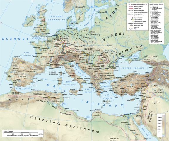
English: Map of the Roman Empire in 125 during the reign of emperor Hadrian.
Projection
Lambert azimuthal-equal area. Central latitude: 45° N, central longitude: 20° E. X, Y origin offset - 0
Datum: ETRS89
Sources
The physical map was made using the following public domain sources:
- Topography: NASA Shuttle Radar Topography Mission (SRTM30) data
- Shoreline, lakes and rivers: derived from Natural Earth data
Additional references for the map content:
- Atlante storico DeAgostini, Instituto Geografico DeAgostini, 1998. pg. 35-41.
- Historischer Weltatlas, Dr. Walter Leisering, Marix Verlag, 2011. pg. 26-27
- Történelmi világatlasz, Cartographia Kiadó, 2005. pg. 20-21.
- The Penguin Historical Atlas of Ancient Rome by Christopher Scarre, Penguin Historical Atlases, 1995. pg. 81.
Software used
GIS:
Graphics editors:
|
| Date |
05.2013 |
| Source |
Own work |
| Author |
|
Permission
( Reusing this file) |
Any use of this map can be made as long as you credit the author, Andrei Nacu (Wikipedia Commons user Andrein), and distribute the copies and derivative works under the same license as that the one stated below.
|
Licensing
I, the copyright holder of this work, hereby publish it under the following licenses:
 |
Permission is granted to copy, distribute and/or modify this document under the terms of the GNU Free Documentation License, Version 1.2 or any later version published by the Free Software Foundation; with no Invariant Sections, no Front-Cover Texts, and no Back-Cover Texts. A copy of the license is included in the section entitled GNU Free Documentation License. http://www.gnu.org/copyleft/fdl.htmlGFDLGNU Free Documentation Licensetruetrue
|
You may select the license of your choice.
|
| Maps of the history of Europe |
BC
aC |
Middle Neolithic · Late Neolithic · 220
|
|
AD
dC |
60 · 125 · 395 · 400 · 450 · 476 · 526 · 526-600 · 800 · 814 · 843-870 · 998 · 1000 · 1092 · 1097 · 1135 · 1142 · 1190 · 1328 · 1360 · 1400 · C.15 · 1430 · 1470 · 1490 · 1500 · 1519 · 1550 · 1560 · 1648 · 1700 · 1708 · 1740 · 1748 · 1787 · 1812 · 1815 · 1815 · 1890 · 1905 · 1911 · 1914 · 1919 · 1919-29 · 1923 · 1941-42 · 1942-45 · 1945-89 · 1993-2006 · 2006 to date
|
| (this template: · view · discuss ) |
File usage
The following pages on Schools Wikipedia link to this image (list may be incomplete):
This file contains additional information, probably added from the digital camera or scanner used to create or digitize it. If the file has been modified from its original state, some details may not fully reflect the modified file.
All five editions of Schools Wikipedia were compiled by SOS Children. More than 2 million people benefit from the global charity work of SOS Childrens Villages, and our work in 133 countries around the world is vital to ensuring a better future for vulnerable children. Sponsoring a child is the coolest way to help.


