
File:Prague Panorama - Oct 2010.jpg
Size of this preview: 640 × 136 pixels.
| |
This is a file from the Wikimedia Commons. Information from its description page there is shown below.
Commons is a freely licensed media file repository. You can help. |
| |
This is a featured picture, which means that members of the community have identified it as one of the finest images on the English Wikipedia, adding significantly to its accompanying article. If you have a different image of similar quality, be sure to upload it using the proper free license tag, add it to a relevant article, and nominate it. |
| |
This image was selected as picture of the day on the English Wikipedia for August 6, 2012. |
|
|
Warning |
Some browsers may have trouble displaying this image at full resolution: This image has a large number of pixels and may either not load properly or cause your browser to freeze. | Interactive large-image-viewer ( non-Flash) |
|---|
Summary
| Description |
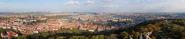
English: A panoramic view of Prague as viewed from Petřín Lookout Tower. The view is approximately 180 degrees, from north on the left to south on the right.
Deutsch: Panoramasicht auf Prag vom Aussichtsturm Petřín aus gesehen. Das Bild deckt rund 180 Grad von Norden nach Süden ab.
|
| Date | 23 October 2010 |
| Source | Own work |
| Author | Diliff |
| Permission ( Reusing this file) |
Summary:
In using this image or any subsequent derivatives of it, you are required to release the image under the same license. As such, any reproduction of this image, in any medium, must appear with a copy of, or full URL of the license. Attribution of this image to the author (DAVID ILIFF) is also required, preferably in a prominent location near the image. No other conditions may be added to, or removed from this license without the permission of the author and copyright holder. Suggested attribution: "Photo by DAVID ILIFF. License: CC-BY-SA 3.0"
|
|
Camera location |
|
This and other images at their locations on: Google Maps - Google Earth - OpenStreetMap | ( Info) |
|---|
Licensing
|

File usage
The following pages on Schools Wikipedia link to this image (list may be incomplete):
Metadata
Learn more
Schools Wikipedia was created by children's charity SOS Children's Villages. SOS Children works in 133 countries and territories across the globe, helps more than 62,000 children, and reaches over 2 million people in total. We have helped children in Africa for many years - you can help too...
Categories: