
File:LocatieRotterdam-2010.png
LocatieRotterdam-2010.png (280 × 130 pixels, file size: 6 KB, MIME type: image/png)
| |
This is a file from the Wikimedia Commons. Information from its description page there is shown below.
Commons is a freely licensed media file repository. You can help. |
| Description |
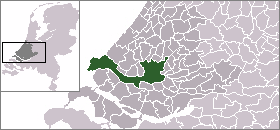
English: Map of Rotterdam: update for 2010 boundary change (addition of Rozenburg)
|
| Date | 2010-04-22 23:13 (UTC) |
| Source |
|
| Author |
|
 |
I, the copyright holder of this work, release this work into the public domain. This applies worldwide. In some countries this may not be legally possible; if so: I grant anyone the right to use this work for any purpose, without any conditions, unless such conditions are required by law.
|
 |
This map image could be recreated using vector graphics as an SVG file. This has several advantages; see Commons:Media for cleanup for more information. If an SVG form of this image is already available, please upload it. After uploading an SVG, replace this template with {{ vector version available|new image name.svg}}. |
File usage
The following pages on Schools Wikipedia link to this image (list may be incomplete):
Learn more about Schools Wikipedia
SOS Childrens Villages chose the best bits of Wikipedia to help you learn. In 133 nations around the world, SOS Childrens Villages works to bring better education and healthcare to families in desperate need of support. Sponsoring a child is the coolest way to help.