
File:Tuareg area.png
| |
This is a file from the Wikimedia Commons. Information from its description page there is shown below.
Commons is a freely licensed media file repository. You can help. |
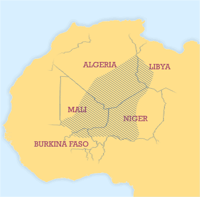
Areas where significant numbers of Tuaregs live.
Sources used to draw this map
- Basset (1952)
- Bernus (1996) Touaregs: un peuple du désert.
- Lhote (1984)
- Sudlow (2001)
- Bougchiche, Lamara. (1997) Langues et litteratures berberes des origines a nos jours. Bibliographie internationale et sytematique. Paris: Ibis Press.
- Zavadovskij (1967)
| This file is licensed under the Creative Commons Attribution 2.5 Generic license. | ||
|
This image was created by Mark Dingemanse and released under the Creative Commons Attribution 2.5 license. The image and any derivatives should be attributed to its creator (Mark Dingemanse) and/or to his agency ( vormdicht); if you choose the latter, please provide a link to www.vormdicht.nl. Feel free to notify me when you're using one of my images outside of the Wikimedia projects; that way, I'll be able to let you know when I release an updated version.
File usage
Schools Wikipedia facts
Schools Wikipedia was created by children's charity SOS Childrens Villages. Thanks to SOS Children, 62,000 children are enjoying a happy childhood, with a healthy, prosperous future ahead of them. You can help by sponsoring a child.