
File:RwandaGeoProvinces.png
RwandaGeoProvinces.png (327 × 317 pixels, file size: 23 KB, MIME type: image/png)
| |
This is a file from the Wikimedia Commons. Information from its description page there is shown below.
Commons is a freely licensed media file repository. You can help. |
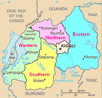
| Description | Map of Rwanda from CIA World Factbook, with province boundaries and names added. |
| Date | 2010-09-24 07:48 (UTC) |
| Source |
|
| Author |
|
| This is a retouched picture, which means that it has been digitally altered from its original version. Modifications: Province boundaries and names added.. The original can be viewed here: Rw-map.png. Modifications made by Amakuru.
|
Copyright information
For the original image:
 |
This image is in the public domain because it contains materials that originally came from the United States Central Intelligence Agency's World Factbook.
|
 |
For the modifications::
|
I, the copyright holder of this work, release this work into the public domain. This applies worldwide. In some countries this may not be legally possible; if so: I grant anyone the right to use this work for any purpose, without any conditions, unless such conditions are required by law.
|
File usage
The following pages on Schools Wikipedia link to this image (list may be incomplete):
Schools Wikipedia and SOS Children
Wikipedia for Schools was collected by SOS Childrens Villages. SOS Children believes education is an important part of a child's life. That's why we ensure they receive nursery care as well as high-quality primary and secondary education. When they leave school, we support the children in our care as they progress to vocational training or higher education. Help another child by taking out a sponsorship.