
File:John 1994 track.png
Size of this preview: 640 × 396 pixels.
| |
This is a file from the Wikimedia Commons. Information from its description page there is shown below.
Commons is a freely licensed media file repository. You can help. |
Summary
| Description |
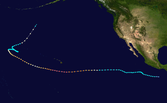
English: Hurricane John (1994) track. Uses the colour scheme from the Saffir-Simpson Hurricane Scale. The points show the location of each storm at 6-hour intervals. The colour represents the storm's maximum sustained wind speeds as classified in the Saffir-Simpson Hurricane Scale (see below), and the shape of the data points represent the nature of the storm.
|
|||||||||||||||||||||||||||||||||||||||||||||||||||||||
| Date | August 11–September 10, 1994 | |||||||||||||||||||||||||||||||||||||||||||||||||||||||
| Source | Created using Wikipedia:WikiProject Tropical cyclones/Tracks. The background image was created by NASA. The tracking data is from the National Hurricane Centre and the Central Pacific Hurricane Centre's Northeast and North Central Pacific hurricane database and or the Joint Typhoon Warning Centre's best track database. | |||||||||||||||||||||||||||||||||||||||||||||||||||||||
| Author | Nilfanion | |||||||||||||||||||||||||||||||||||||||||||||||||||||||
Licensing
 |
This work has been released into the public domain by its author, Nilfanion. This applies worldwide. In some countries this may not be legally possible; if so: Nilfanion grants anyone the right to use this work for any purpose, without any conditions, unless such conditions are required by law.
|
File usage
The following pages on Schools Wikipedia link to this image (list may be incomplete):
I want to learn more...
Schools Wikipedia was created by children's charity SOS Childrens Villages. SOS Children is a global charity founded in 1949 to give children who have lost everything the childhood they deserve. Help another child by taking out a sponsorship.