
File:NYC Top of the Rock Pano.jpg
| |
This is a file from the Wikimedia Commons. Information from its description page there is shown below.
Commons is a freely licensed media file repository. You can help. |
| |
This is a featured picture, which means that members of the community have identified it as one of the finest images on the English Wikipedia, adding significantly to its accompanying article. If you have a different image of similar quality, be sure to upload it using the proper free license tag, add it to a relevant article, and nominate it. |
|
||||||
| Description |
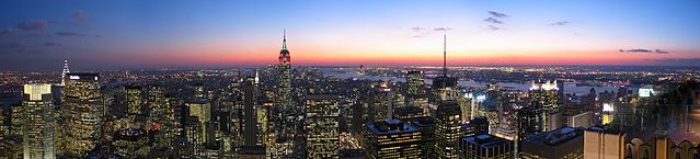
Deutsch: Panoramaaufnahme vom der oberen Aussichtsplattform Top of the Rock auf dem GE Building im Rockefeller Centre in Manhattan, New York.
Unter anderem zu sehen sind von links nach rechts das Chrysler Building (hinter dem MetLife Building), Manhattan Bridge, Brooklyn Bridge, Verrazano-Narrows-Brücke (am Horizont), MetLife Tower (mit der weiss beleuchteten Spitze), das Empire State Building (in rot grüner Weihnachtsbeleuchtung) und das Condé Nast Building (mit dem großen Mast). Die untere Aussichtsplattform mit ihrer gläsernen Barriere ist am rechten Rand zu sehen.English: Panoramic image looking south from the upper deck of the 'Top of the Rock' observation deck on Rockefeller Centre. Lower deck is visible on the right edge of the frame.
Français : Image panoramique en regardant vers le sud depuis la terrasse supérieure "Top of the Rock" du Rockefeller Centre. La terrasse inférieure est visible sur la droite.
|
||||||||
| Date | 6 December 2005 | ||||||||
| Source | Own work | ||||||||
| Author | Daniel Schwen | ||||||||
| Permission ( Reusing this file) |
|

|
Camera location |
|
View this and other nearby images on: Google Maps - Google Earth - OpenStreetMap | ( Info) |
|---|
| Panorama-overlay |
view this Panorama with Wikipedia-articles overlay |
( Help) |
|---|
| Annotations | This image is annotated: View the annotations at Commons |
File usage
Did you know...?
Through Schools Wikipedia, SOS Childrens Villages has brought learning to children around the world. SOS Children's Villages is an international children's charity, providing a good home and loving family to thousands of children who have lost their parents. We also work with communities to help vulnerable families stay together and raise children in the best possible environment. Will you help another child today?