Checked content

File:Japan location map with side map of the Ryukyu Islands.svg

Summary

Description
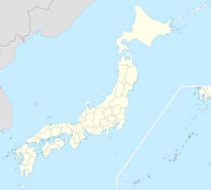
Deutsch: Postionskarte von Japan

Quadratische Plattkarte.

Bei Nutzung der Hauptkarte mit den Hauptinseln gelten folgende geographische Begrenzungen für die (Gesamt-)Karte:

  • N: 45°51'37" N (45.86°N)
  • S: 30°01'13" N (30.02°N)
  • W: 128°14'24" O (128.24°O)
  • O: 149°16'13" O (149.27°O)

Bei Nutzung der Nebenkarte mit den Ryūkyū-Inseln gelten folgende geographische Begrenzungen für die (Gesamt-)Karte:

  • N: 39°32'25" N (39.54°N)
  • S: 23°42'36" N (23.71°N) http://tv02.search.naver.net/ugc?t=r115&q=http://cafefiles.naver.net/20120812_79/digiliti_1344752344680sQDL1_PNG/2012-08-12_15%3B06%3B46.png
  • W: 110°25'49" O (110.43°O)
  • O: 131°26'25" O (131.44°O)


English: Location map of Japan

Equirectangular projection.

Geographic limits to locate objects in the main map with the main islands:

  • N: 45°51'37" N (45.86°N)
  • S: 30°01'13" N (30.02°N)
  • W: 128°14'24" E (128.24°E)
  • E: 149°16'13" E (149.27°E)

Geographic limits to locate objects in the side map with the Ryukyu Islands:

  • N: 39°32'25" N (39.54°N)
  • S: 23°42'36" N (23.71°N)
  • W: 110°25'49" E (110.43°E)
  • E: 131°26'25" E (131.44°E)
Date March 2010
Source Own work
Author Maximilian Dörrbecker ( Chumwa)
Permission
( Reusing this file)
I, the copyright holder of this work, hereby publish it under the following licenses:
GNU head Permission is granted to copy, distribute and/or modify this document under the terms of the GNU Free Documentation License, Version 1.2 or any later version published by the Free Software Foundation; with no Invariant Sections, no Front-Cover Texts, and no Back-Cover Texts. A copy of the license is included in the section entitled GNU Free Documentation License.

w:en:Creative Commons
attribution share alike
This file is licensed under the Creative Commons Attribution-Share Alike 3.0 Unported license.
You are free:
  • to share – to copy, distribute and transmit the work
  • to remix – to adapt the work
Under the following conditions:
  • attribution – You must attribute the work in the manner specified by the author or licensor (but not in any way that suggests that they endorse you or your use of the work).
  • share alike – If you alter, transform, or build upon this work, you may distribute the resulting work only under the same or similar license to this one.

You may select the license of your choice.
Terra globe icon light.png

This map has been made or improved in the German Kartenwerkstatt (Map Lab). You can propose maps to improve as well.


The following pages on Schools Wikipedia link to this image (list may be incomplete):

Metadata

Want to know more?

SOS Childrens Villages chose the best bits of Wikipedia to help you learn. SOS Children cares for children who have lost their parents. Our Children's Villages give these children a new home and a new family, while a high-quality education and the best of medical care ensures they will grow up with all they need to succeed in adult life. Sponsoring a child is the coolest way to help.