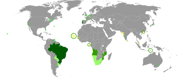
File:Map of the portuguese language in the world.png

Size of this preview: 640 × 282 pixels.
| |
This is a file from the Wikimedia Commons. Information from its description page there is shown below.
Commons is a freely licensed media file repository. You can help. |
Summary
| DescriptionMap of the portuguese language in the world.png |
See below |
| Date | 29 May 2011 |
| Source | Wikipedia en español, portugués, inglés y francés. |
| Author | Jonatan argento |
English: Map of the portuguese language in the world
- Dark green: native language.
- Green: official and administrative language.
- Light green: cultural or secondary language.
- Yellow: portuguese-based creole.
- Green square: portuguese speaking minorities.
Français : Carte de la langue portugaise dans le monde
- Vert foncé: langue maternelle.
- Vert: langue officielle et administrative.
- Vert clair: langue culturelle ou secondaire.
- Jaune:créole de base portugaise.
- Carré vert: minorités parlant le portugais.
Español: Mapa del idioma portugués en el mundo
- Verde oscuro: lengua materna.
- Verde: lengua oficial y administrativa.
- Verde claro: lengua cultural o secundaria.
- Amarillo: criollo de base portuguesa.
- Cuadrado verde: minorías hablantes de portugués.
Português: Mapa da língua portuguesa no mundo
- Verde escuro: língua materna.
- Verde: língua oficial e administrativa.
- Verde claro: língua cultural ou secundária.
- Amarelo: crioulo de base portuguesa.
- Quadrado verde: minorias falantes de português.
Italiano: Mappa della lingua portoghese nel mondo
- Verde scuro: lingua materna.
- Verde: lingua ufficiale e amministrativa.
- Verde chiaro: lingua culturale o secondaria.
- Giallo: Creolo portoghese.
- Quadrati verdi: minoranze di lingua portoghese.
Deutsch: Karte der portugiesischen Sprache auf der Welt
- Dunkelgrün: Muttersprache.
- Grün: offizielle und administrative Sprache.
- Hellgrün: Kultur-oder Zweitsprache.
- Gelb: portugiesischbasierte Kreolsprache.
- Grünes Quadrat: portugiesischsprachige Minderheiten.
Gaeilge: Léarscáil na teanga Portaingéilis ar fud an domhain
- Glas Dorcha: dteanga dhúchais.
- Glas: theanga oifigiúil agus riaracháin.
- Solas glas: teanga chultúrtha nó thánaisteach.
- Buí: Portaingéilis-bhunaithe Creole.
- Cearnach glas: mionlaigh a labhraíonn Portaingéilis.
Lëtzebuergesch: Kaart vun der portugisescher sprooch op der welt
- Donkelgréng: Mammesprooch.
- Gréng: offiziell an administrativ Sprooch.
- Hellgréng: Kultur- oder Zweetsprooch.
- Giel: portugiseschbaséiert Kreolsprooch.
- Gréng Carréen: portugiseschsproocheg Minoritéiten.
Licensing
|
 |
This map image could be recreated using vector graphics as an SVG file. This has several advantages; see Commons:Media for cleanup for more information. If an SVG form of this image is already available, please upload it. After uploading an SVG, replace this template with {{ vector version available|new image name.svg}}. |
File usage
The following pages on Schools Wikipedia link to this image (list may be incomplete):
Metadata
This file contains additional information, probably added from the digital camera or scanner used to create or digitize it. If the file has been modified from its original state, some details may not fully reflect the modified file.
| Horizontal resolution | 37.8 dpc |
|---|---|
| Vertical resolution | 37.8 dpc |
| Software used |
|
Find out about Schools Wikipedia
SOS Children's Villages has brought Wikipedia to the classroom. Our 500 Children's Villages provide a home for thousands of vulnerable children. Beyond our Villages, we support communities, helping local people establish better schools and delivering effective medical care to vulnerable children. Have you heard about child sponsorship? Visit our web site to find out.

