Checked content

File:King williams war.svg

Description
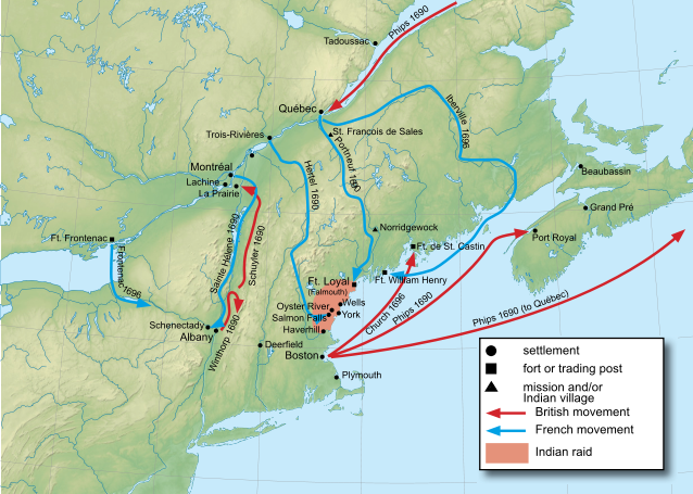
English: Map of King William's War.
Date 2011-05-25 11:50 (UTC)
Source
Author
  • derivative work: Hoodinski ( talk)


Applications-graphics.svg This is a retouched picture, which means that it has been digitally altered from its original version. Modifications: added towns, army movements and campaign. The original can be viewed here: New_England_and_South-East_of_Canada_topographic_map-blank.svg. Modifications made by Hoodinski.

I, the copyright holder of this work, hereby publish it under the following licenses:
w:en:Creative Commons
attribution share alike
This file is licensed under the Creative Commons Attribution-Share Alike 3.0 Unported, 2.5 Generic, 2.0 Generic and 1.0 Generic license.
You are free:
  • to share – to copy, distribute and transmit the work
  • to remix – to adapt the work
Under the following conditions:
  • attribution – You must attribute the work in the manner specified by the author or licensor (but not in any way that suggests that they endorse you or your use of the work).
  • share alike – If you alter, transform, or build upon this work, you may distribute the resulting work only under the same or similar license to this one.

GNU head Permission is granted to copy, distribute and/or modify this document under the terms of the GNU Free Documentation License, Version 1.2 or any later version published by the Free Software Foundation; with no Invariant Sections, no Front-Cover Texts, and no Back-Cover Texts. A copy of the license is included in the section entitled GNU Free Documentation License.

You may select the license of your choice.
The following pages on Schools Wikipedia link to this image (list may be incomplete):

Metadata

I want to learn more...

SOS Children has brought Wikipedia to the classroom. Thanks to SOS Children's Villages, 62,000 children are enjoying a happy childhood, with a healthy, prosperous future ahead of them. There are many ways to help with SOS Childrens Villages.