File:Iceberg with hole near sanderson hope 2007-07-28 2.jpg

| |
This is a file from the Wikimedia Commons. Information from its description page there is shown below.
Commons is a freely licensed media file repository. You can help. |
| |
This is a featured picture, which means that members of the community have identified it as one of the finest images on the English Wikipedia, adding significantly to its accompanying article. If you have a different image of similar quality, be sure to upload it using the proper free license tag, add it to a relevant article, and nominate it. |
| |
This image was selected as picture of the day on the English Wikipedia for October 24, 2008. |
|
 |
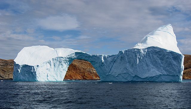
This image was selected as picture of the day on Wikimedia Commons for 29 June 2008. It was captioned as follows: English: Iceberg between Langø and Sanderson Hope, south of Upernavik, Greenland.
Other languages:
Alemannisch: Isbärgä zwüscha Langø u Sanderson Hope südlich vo Upernavik, Grönland.
العربية: جبل جليدي في جنوب أبرنافيك ، جرينلاند.
Беларуская: Айсберг паміж Ланго і Сандэрсан-Хоўп, на поўдзень ад Упернавіка (Грэнландыя).
Bosanski: Ledeni brijeg između Langø-a and Sanderson Hope-a, južno od Upernavik-a, Grenland.
Català: Un iceberg entre Langø et Sanderson Hope, al sud de Upernavik, a Groenlàndia.
Česky: Ledovec jižně od města Upernavik v Grónsku
Dansk: Isbjerg mellem Langø og Sanderson Hope, syd for Upernavik, Grønland.
Deutsch: Ein Eisberg zwischen Langø and Sanderson Hope, südlich von Upernavik, Grönland.
English: Iceberg between Langø and Sanderson Hope, south of Upernavik, Greenland.
Esperanto: Glacimonto inter Langø kaj Sanderson Hope sude de la urbo Upernavik, Gronlando
Español: Un iceberg entre Langø y Sanderson Hope, al sur de Upernavik, Groenlandia.
Français : Un iceberg entre Langø et Sanderson Hope, au sud de Upernavik, Groenland.
Magyar: Jéghegy Langø és Sanderson Hope között, Upernaviktól délre ( Grönland)
Íslenska: Borgarísjaki við Qaarsorsuaq sunnan við Upernarvik á norðvesturhluta Grænlands.
Italiano: Un iceberg al largo di Qaarsorsuaq, Groenlandia.
日本語: Langø とサンダーソン・ホープの間の 氷山 グリーンランド、 ウペルナビク南部にて
한국어: 그린란드 우퍼나비크 남쪽 랑괴와 샌더슨 호프 사이에 있는 빙산
Lietuvių: Ledkalnis Upernavik miestelio pietuose, Grenlandijoje.
Nederlands: IJsberg tussen Langø en Qaarsorsuaq (Sanderson Hope) ten zuiden van de plaats Upernavik in het noordwesten van Groenland
Polski: Zdjęcie góra lodowej wykonane pomiędzy zatokami Langø i Sanderson na południe od Upernavik w Grenlandii.
Português: Um iceberg, ao largo de Qaarsorsuaq, na Gronelândia.
Русский: Айсберг у берегов южного Упернавика ( Гренландия)
Svenska: Ett isberg med ett hål i, i sundet mellan Langø och Sanderson Hope söder om Upernavik på Grönland.
Українська: Айсберг між Ланґьо (Langø) і Сандерсон Хоуп (Sanderson Hope), на південь від Упернавіку (Upernavik), Гренландія
中文(简体): 格陵兰乌佩纳维克朗岛和桑德森角之间的冰山
中文(繁體): 格陵蘭 烏佩納維克朗島和桑德森角之間的 冰山
|
 |
This is one of the images forming part of the Valued image set: The deterioration of an iceberg on Wikimedia Commons. The image set has been assessed under the valued image set criteria and is considered the most valued set on Commons within the scope: You can see its nomination at Commons:Valued image candidates/Iceberg deterioration. |
Summary
| Description |
Dansk: Isbjerg med hul i strædet mellem Langø og Sanderson Hope syd for Upernavik, Grønland.
English: Iceberg with a hole in the strait between Langø and Sanderson Hope south of Upernavik, Greenland.
Français : Un Iceberg percé d'un trou dans le détroit entre Langø et Sanderson Hope au sud d'Upernavik, au Groenland.
|
| Date | 28 July 2007 |
| Source | Own work (Own photo) |
| Author | Kim Hansen |
|
Camera location |
72° 44′ 8.30″ N, 56° 10′ 44.30″ W |
This and other images at their locations on: Google Maps - Google Earth - OpenStreetMap | ( Info)72.735638888889;-56.178972222222 |
|---|
Licensing
|
File usage
Metadata
| Camera manufacturer | Canon |
|---|---|
| Camera model | Canon DIGITAL IXUS 800 IS |
| Exposure time | 1/500 sec (0.002) |
| F-number | f/6.3 |
| Date and time of data generation | 14:35, 28 July 2007 |
| Lens focal length | 8.636 mm |
| Orientation | Normal |
| Horizontal resolution | 180 dpi |
| Vertical resolution | 180 dpi |
| File change date and time | 14:35, 28 July 2007 |
| Y and C positioning | Centered |
| Exif version | 2.2 |
| Date and time of digitizing | 14:35, 28 July 2007 |
| Meaning of each component |
|
| Image compression mode | 5 |
| Shutter speed | 8.96875 |
| APEX aperture | 5.3125 |
| Exposure bias | 0 |
| Maximum land aperture | 3.34375 APEX (f/3.19) |
| Metering mode | Pattern |
| Flash | Flash did not fire, auto mode, red-eye reduction mode |
| Supported Flashpix version | 0,100 |
| Colour space | sRGB |
| Focal plane X resolution | 12,515.555555556 |
| Focal plane Y resolution | 12,497.041420118 |
| Focal plane resolution unit | inches |
| Sensing method | One-chip colour area sensor |
| File source | Digital still camera |
| Custom image processing | Normal process |
| Exposure mode | Auto exposure |
| White balance | Auto white balance |
| Digital zoom ratio | 1 |
| Scene capture type | Standard |
Background information
Schools Wikipedia was created by children's charity SOS Children. The world's largest orphan charity, SOS Children brings a better life to more than 2 million people in 133 countries around the globe. There are many ways to help with SOS Children.

