
File:Transasia trade routes 1stC CE gr2.png
| |
This is a file from the Wikimedia Commons. Information from its description page there is shown below.
Commons is a freely licensed media file repository. You can help. |
 |
This map image could be recreated using vector graphics as an SVG file. This has several advantages; see Commons:Media for cleanup for more information. If an SVG form of this image is already available, please upload it. After uploading an SVG, replace this template with {{ vector version available|new image name.svg}}. |
Contents |
Licensing
|
Map information
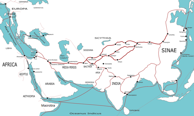
This map indicates trading routes used around the 1st century CE centred on the Silk Road. The routes remain largely valid for the period 500 BCE to 500 CE.
Geographical labels for regions are adapted from the Geography of Ptolemy (c. 150 CE), some trading centre names date from later (c. 400 CE). Relying on Ptolemy's names is wrong but neutral.
The following contemporary trading centres (or possible trading centres) are not marked:
Red Sea - Myos Hormos, Berenica, Ptolemais Theron, Adulis, Muza, Ocalis, Aualites, Malao.
Arabia - [South] Saue, Sana, Saphar, Eudaemon Arabia, Cane, Mosyllon, Moscha
Persian Gulf - Asabon, Charax, Gerra, Ommana, Apologos
Persia - Persepolis, Alexandria Areion, Kandahar
Africa - [East Africa/Kush/Axum] Coloe, Axum, Akhmim, Panopolis, Aromaton Emporion, Opone, Sarapion, Dongola. [Mediterranean] Cyrene, Leptis Magna, Carthage, Caesarea, [Beyond map] [East Africa] Juba, Maji, Sennar, [Trans-Saharan] Sijilmassa, Tamanrasset, Murzuk, Tingis.
Europe - Gades (Cadiz), Augusta Treverorum (Trier), Aquileia, Ostia, Athens
India - [Arabian Sea] Horaia, Barbaricum, Barake, Astakapra, Suppara, Kalliena, Semylla, Mandagora, Palaepatmae, Melizeigara, Erannoboas, Byzantion, Naura, Tymdis, [Central] Paethana, Tagara, [South] Muziris, Nelcynda, Bacare, Balita, Colchi, Palaesimundu, [East] Argaru, Poduca, Sopatma.
Silk Road - Ecbatana, Yarkand, Jiaohei, Kitai, Kaifeng. (Note - both summer and winter routes around the Takla Makan are shown)
China - Chengdu, Kunming, Cattgara
South East Asia - Trang, Thaton
The routes between most of these unindicated sites are not marked, notably the extensive European/Roman routes and the other routes in Persia beyond the Silk Road. Another route not indicated is the Scythian route running from China to the Black Sea. The large number not marked on India are the minor sites listed in the Periplus of the Erythraean Sea.
Origins of trade goods
China - silk, clothing, lacquerware, spices
Indo-China - spices, ivory, timber, pearls
Northern India - precious stones, ivory, tortoiseshell, incense, spices, cloth, timber
Southern India - ivory, tortoiseshell, spices, precious stones, cloth, timber
Arabia - spices, slaves, precious stones
East Africa - gold, ivory, exotic animals, slaves, incense
Trans-Sahara - ivory, gold, slaves
North Africa - grain,
Southern Europe - olive oil, wine, glassware, coinage
Western Europe - silver, tin
Northern Europe - slaves, amber,
Asia Minor - silver, precious stones, timber, wine
Image editing
The source for this PNG was an SVG. This file is available.
from en wp
(del) (cur) 23:55, 30 March 2006 . . TwoOneTwo (Talk) . . 1223x794 (374899 bytes)
- (cur) (last) 00:12, 31 March 2006 82.24.208.109 (→Map information)
- (cur) (last) 00:00, 31 March 2006 TwoOneTwo m
- (cur) (last) 23:55, 30 March 2006 TwoOneTwo
| Annotations | This image is annotated: View the annotations at Commons |
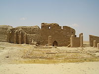 Dura-Europos
File usage
Metadata
Schools Wikipedia and SOS Children
Through Schools Wikipedia, SOS Childrens Villages has brought learning to children around the world. SOS Childrens Villages cares for children who have lost their parents. Our Children's Villages give these children a new home and a new family, while a high-quality education and the best of medical care ensures they will grow up with all they need to succeed in adult life. Sponsoring a child is a great way to help children who need your support.