 |
This is a file from the Wikimedia Commons. Information from its description page there is shown below.
Commons is a freely licensed media file repository. You can help.
|
Summary
| Description |
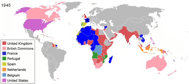
The colors represent the colonies of various nations in 1945, and the colonial borders of that time. English: Colonisation in 1945
Français : Les couleurs représentent les colonies des diverses pays en 1945 et les frontières coloniales de l'époque.
Español: Colonialismo en 1945
한국어: 1945년의 국가들
|
| Date |
(unknown) |
| Source |
File:Colonisation2.gif |
| Author |
|
Permission
( Reusing this file) |
|
See also
| Maps of world history |
| BC |
2000 · 1000 · 500 · 400 · 323 · 300 · 200 · 100 · 50
|
|
| AD |
1 · 50 · 100 · 200 · 250 · 300 · 400 · 500 · 700 · 750 · 820 · 900 · 1959 · 1980 ·
|
|
|
Maps of colonization history
1492 · 1550 · 1660 · 1754 · 1800 · 1822 · 1885 · 1898 · 1914 · 1920 · 1936 · 1938 · 1945 · 1959 · 1974 · 2007
|
|
|
see also: Eastern Hemisphere only maps template (1300BC-1500AD)
|
| (this template: · view · discuss ) |
File usage
The following pages on Schools Wikipedia link to this image (list may be incomplete):
This file contains additional information, probably added from the digital camera or scanner used to create or digitize it. If the file has been modified from its original state, some details may not fully reflect the modified file.
You can learn about nearly 6,000 different topics on Schools Wikipedia. SOS Children's Villages helps more than 2 million people across 133 countries around the world. Sponsoring a child is the coolest way to help.


