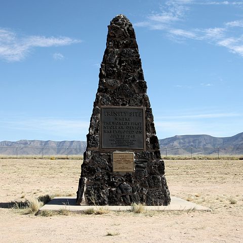
File:Trinity Site Obelisk National Historic Landmark.jpg

| |
This is a file from the Wikimedia Commons. Information from its description page there is shown below.
Commons is a freely licensed media file repository. You can help. |
|
This is an image of a place or building that is listed on the National Register of Historic Places in the United States. Its reference number is 66000493. |
| Description | Looking at the Trinity Site obelisk, head-on. The black plaque on top reads: Trinity Site Where The World's First Nuclear Device Was Exploded On July 16, 1945 Erected 1965 White Sands Missile Range J Frederick Thorlin Major General U.S. Army Commanding The gold plaque below it declares the site a National Historic Landmark, and reads: Trinity Site has been designated a National Historical Landmark This Site Possesses National Significance In Commemorating The History of the United States of America 1975 National Park Service United States Department of the Interior |
|||||||
| Date | 2 October 2010, 12:00:57 | |||||||
| Source | Flickr: Trinity Site Obelisk National Historic Landmark | |||||||
| Author | Samat Jain | |||||||
| Permission ( Reusing this file) |
|
|
Camera location |
33° 40′ 38.13″ N, 106° 28′ 31.64″ W |
This and other images at their locations on: Google Maps - Google Earth - OpenStreetMap | ( Info)33.6772584;-106.47545545 |
|---|
File usage
Metadata
| Camera manufacturer | Canon |
|---|---|
| Camera model | Canon EOS 50D |
| Exposure time | 1/250 sec (0.004) |
| F-number | f/10 |
| ISO speed rating | 100 |
| Date and time of data generation | 12:00, 2 October 2010 |
| Lens focal length | 20 mm |
| Altitude | 1,475.297 meters above sea level |
| Width | 2,530 px |
| Height | 2,530 px |
| Orientation | Normal |
| Horizontal resolution | 72 dpi |
| Vertical resolution | 72 dpi |
| Software used | digiKam-1.4.0 |
| File change date and time | 12:00, 2 October 2010 |
| Y and C positioning | Co-sited |
| Exposure Program | Not defined |
| Exif version | 2.21 |
| Date and time of digitizing | 12:00, 2 October 2010 |
| Shutter speed | 8 |
| APEX aperture | 6.625 |
| Exposure bias | 0 |
| Metering mode | Pattern |
| Flash | Flash did not fire, compulsory flash suppression |
| DateTime subseconds | 47 |
| DateTimeOriginal subseconds | 47 |
| DateTimeDigitized subseconds | 47 |
| Colour space | sRGB |
| Focal plane X resolution | 5,315.4362416107 |
| Focal plane Y resolution | 5,306.5326633166 |
| Focal plane resolution unit | inches |
| Custom image processing | Normal process |
| Exposure mode | Auto exposure |
| White balance | Auto white balance |
| Scene capture type | Standard |
| North or south latitude | North latitude |
| East or west longitude | West longitude |
| Geodetic survey data used | WGS-84 |
I want to learn more...
Schools Wikipedia was created by children's charity SOS Children's Villages. SOS Children's Villages believes education is an important part of a child's life. That's why we ensure they receive nursery care as well as high-quality primary and secondary education. When they leave school, we support the children in our care as they progress to vocational training or higher education. We have helped children in Africa for many years - you can help too...
