 |
This is a file from the Wikimedia Commons. Information from its description page there is shown below.
Commons is a freely licensed media file repository. You can help.
|
Summary
| DescriptionEuropean settlements in India 1501-1739.png |
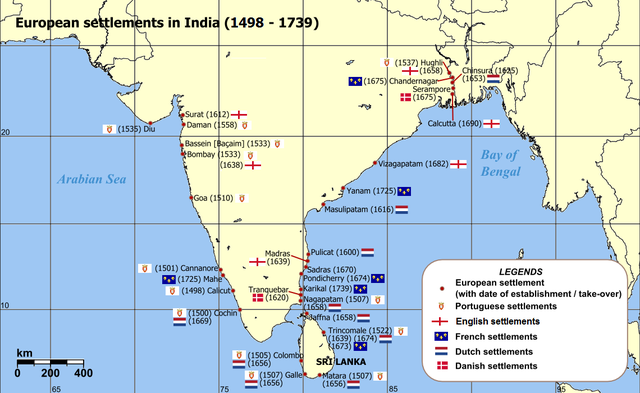
English: Map of India with Sri Lanka, illustrating locations of European settlements in the subcontinent between 1501 and 1739.
Norsk nynorsk: Kart over Sør-Asia med europeiske koloniar/busetjingar mellom 1501 og 1739.
Dansk: Kort af Indien inkl. Sri Lanka med europæiske kolonier mellem 1501 og 1739.
|
| Date |
uploaded in 2006 |
| Source |
Self-published work by Luis wiki Map reference: at w:University of Pennsylvania, with reference varification from: (URL accessed: 23-Mar-2006) |
| Author |
Luis wiki |
 |
This map image could be recreated using vector graphics as an SVG file. This has several advantages; see Commons:Media for cleanup for more information. If an SVG form of this image is already available, please upload it. After uploading an SVG, replace this template with {{ vector version available|new image name.svg}}. |
Licensing
|
I, the copyright holder of this work, hereby publish it under the following license:
|
File usage
The following pages on Schools Wikipedia link to this image (list may be incomplete):
This file contains additional information, probably added from the digital camera or scanner used to create or digitize it. If the file has been modified from its original state, some details may not fully reflect the modified file.
This selection has made Wikipedia available to all children. By supporting vulnerable children right through to adulthood, SOS Childrens Villages makes a lasting difference to the lives of thousands of people. Education is a key part of our work, and our schools provide high-quality teaching to the children in our care. Would you like to sponsor a child?


