|
This is a file from the Wikimedia Commons. Information from its description page there is shown below.
Commons is a freely licensed media file repository. You can help.
|
Summary
| Description |
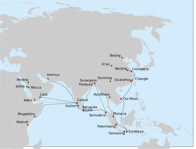
Deutsch: Route der 7. Expedition der Schatzschiffe von Zheng He (1431-1433).
- Durchgezogene Linie: die Route der Hauptflotte von Nanjing nach Hormuz, wie in Xia Xiyang (下西洋) beschrieben.
- Strichlinie: eine mögliche Route von Hong Bao's Abteilung nach Bengalen, Arabien und Afrika entsprechend der Vorschläge von Dreyer (2007) (auf Grundlage von Ma Huan's Ying-yai Sheng-lan (瀛涯胜览), Ming shi und anderen Quellen.
- Punktlinie: Reise von 7 chinesischen Aufklärern mit indischen (oder arabischen(?) Schiffen) und per Karawane von Kalkutta nach Mekka und Medina.
- Rote Kreise: Städte die wahrscheinlich von der Flotte (oder von Teilen der Flotte) auf der 7. und/oder früheren Expeditionen besucht wurden.
- Grüne Kreise: wichtige Plätze aus der Biografie von Zheng He und die von Ma Huan besuchten arabischen Städte.
Hauptquelle: Kapitel in der letzten Expedition von Zheng He in: Dreyer E. L., Zheng He: China and the Oceans in the Early Ming Dynasty, 1405-1433. — Longman, 2007. — 256 p. — (Library of World Biography Series). — ISBN 0321084438 (engl.).
English: Route of the 7th expedition of Zheng He's fleet (1431-1433).
- Solid line: the route of the main fleet from Nanjing to Hormuz, as described in Xia Xiyang (下西洋).
- Dashed line: a possible route of Hong Bao's squadron, to Bengal, Arabia and Africa, based on suggestions made in Dreyer (2007) (who uses Ma Huan's Ying-yai Sheng-lan (瀛涯胜览), Ming shi and other sources.
- Dotted line: travel of 7 Chinese explorers, on an Indian (or Arab? vessel) and by caravan from Calicut to Mecca and Medina.
- Red circles: cities thought to have been visited by the fleets of Zheng He, or the elements of the fleet, on the 7th and/or earlier voyages.
- Green circles: important places in the biography of Zheng He, and Arabian cities visited by Ma Huan.
The main source for all routes: chapter on the last expedition of Zheng He in: Dreyer E. L., Zheng He: China and the Oceans in the Early Ming Dynasty, 1405-1433. — Longman, 2007. — 256 p. — (Library of World Biography Series). — ISBN 0321084438. The cities in Bengal are given as per : Barbosa, Duarte & Dames, Mansel Longworth (1996), An Account Of The Countries Bordering On The Indian Ocean And Their Inhabitants; Written By Duarte Barbosa And Completed About The Year 1518 A.D. Vol 1: Including The Coasts Of East Africa, Arabia, Persia And Western India As Far As The Kingdom Of Vijayanagar. Vol. Ii: Including The Coasts Of Malabar, Eastern India, Further India, China And The Indian Archipelago., Asian Educational Services, pp. 138-139, ISBN 8120604512
Русский: Маршрут 7-го плавания китайского флота под общим командованием Чжэн Хэ и Ван Цзинхуна (1431-1433 гг). Сплошная линия путь главного флота из Китая в Ормуз (известена достаточно достоверно); прерывистая - эскадра Хун Бао (предположительно); пунктир - путь 7 китайцев (включая Ма Хуаня) из Каликута в Мекку и Медину
|
| Date |
24 August 2010 |
| Source |
Own work |
| Author |
Vmenkov, based on the blank map File:Asie.svg (ver. 1) by User:Historicair |
Licensing
I, the copyright holder of this work, hereby publish it under the following licenses:

 |
This file is licensed under the Creative Commons Attribution 1.0 Generic license. |
|
|
|
- You are free:
- to share – to copy, distribute and transmit the work
- to remix – to adapt the work
- Under the following conditions:
- attribution – You must attribute the work in the manner specified by the author or licensor (but not in any way that suggests that they endorse you or your use of the work).
http://creativecommons.org/licenses/by/1.0 CC-BY-1.0 Creative Commons Attribution 1.0 truetrue
|
 |
Permission is granted to copy, distribute and/or modify this document under the terms of the GNU Free Documentation License, Version 1.2 or any later version published by the Free Software Foundation; with no Invariant Sections, no Front-Cover Texts, and no Back-Cover Texts. A copy of the license is included in the section entitled GNU Free Documentation License. http://www.gnu.org/copyleft/fdl.htmlGFDLGNU Free Documentation Licensetruetrue
|
You may select the license of your choice.
|
File usage
The following pages on Schools Wikipedia link to this image (list may be incomplete):
This file contains additional information, probably added from the digital camera or scanner used to create or digitize it. If the file has been modified from its original state, some details may not fully reflect the modified file.
Schools Wikipedia was created by children's charity SOS Children's Villages. More than 2 million people benefit from the global charity work of SOS Children, and our work in 133 countries around the world is vital to ensuring a better future for vulnerable children. Have you heard about child sponsorship? Visit our web site to find out.