 |
This is a file from the Wikimedia Commons. Information from its description page there is shown below.
Commons is a freely licensed media file repository. You can help.
|
Summary
| Description |
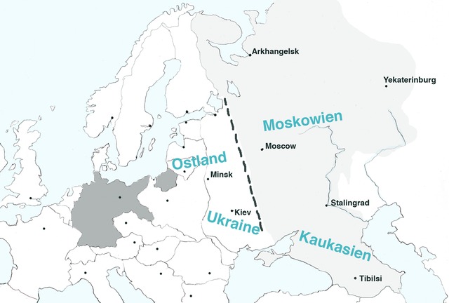
English: Map of Europe, with pre-WW2 borders, showing the extension of Nazi Germany's GENERALPLAN OST worked out 1940-1942.Legend: Dark grey – Germany (Deutsches Reich). Dotted black line – the extension of detailed plans of a second ”phase of settlement” (Siedlungsphase). Light grey – the greatest extension of Generalplan Ost. The names in blue - nazi regions called Reichskommissariat : Ostland (1941-1945), Ukraine (1941-1945), Moskowien (never realized), Kaukasien (never realized). The map is based on texts and graphics on Deutsches Forschungsgemainschaft: Der Generalplan Ost der Nationalsozialisten,
|
| Date |
10 April 2011 |
| Source |
Own work |
| Author |
Lihagen |
Permission
( Reusing this file) |
| Public domainPublic domainfalsefalse |
 |
I, the copyright holder of this work, release this work into the public domain. This applies worldwide.
In some countries this may not be legally possible; if so:
I grant anyone the right to use this work for any purpose, without any conditions, unless such conditions are required by law.Public domainPublic domainfalsefalse
|
|
Licensing
I, the copyright holder of this work, hereby publish it under the following license:
  |
This file is made available under the Creative Commons CC0 1.0 Universal Public Domain Dedication. |
| The person who associated a work with this deed has dedicated the work to the public domain by waiving all of his or her rights to the work worldwide under copyright law, including all related and neighboring rights, to the extent allowed by law. You can copy, modify, distribute and perform the work, even for commercial purposes, all without asking permission. http://creativecommons.org/publicdomain/zero/1.0/deed.enCC0Creative Commons Zero, Public Domain Dedicationfalsefalse
|
|
File usage
The following pages on Schools Wikipedia link to this image (list may be incomplete):
This file contains additional information, probably added from the digital camera or scanner used to create or digitize it. If the file has been modified from its original state, some details may not fully reflect the modified file.
SOS Childrens Villages has brought Wikipedia to the classroom. By supporting vulnerable children right through to adulthood, SOS Childrens Villages makes a lasting difference to the lives of thousands of people. Education is a key part of our work, and our schools provide high-quality teaching to the children in our care. Sponsoring a child is the coolest way to help.


