 |
This is a file from the Wikimedia Commons. Information from its description page there is shown below.
Commons is a freely licensed media file repository. You can help.
|
| Description |
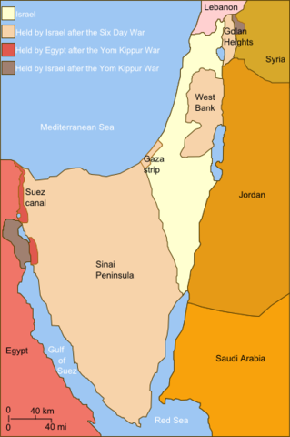
Self-made line drawing of a map Israel's ceasefire lines with its neighboring countries after its establishment (1949), after the Six Day War (June 1967) and the last front line after Yom Kippur War (late October 1973). After the latter. Author: User:Raul654 Source of line drawing: Now-deleted image Image:Jom kippur war.jpg, which was originally uploaded to the polish Wikipedia at http://pl.wikipedia.org/wiki/Grafika:Jom_kippur_war.jpg -- Ministerstwo Spraw Zagranicznych Izraela, za zgodÄ… Ambasady Izraela w Polsce. -- Ministry of Foreign Affairs of Israel, with the permission of Israel Embassy in Poland |
| Date |
2010-12-02 11:02 (UTC) |
| Source |
|
| Author |
- derivative work: Supreme Deliciousness ( talk)
|
 |
This is a retouched picture, which means that it has been digitally altered from its original version. Modifications: Israeli territory before the Six day war is the same as after. The original can be viewed here: Yom_Kippur_War_map.svg. Modifications made by User:Personal tools * Supreme Deliciousness.
|
|
I, the copyright holder of this work, hereby publish it under the following license:
|
File usage
The following pages on Schools Wikipedia link to this image (list may be incomplete):
SOS Children chose the best bits of Wikipedia to help you learn. Thanks to SOS Childrens Villages, 62,000 children are enjoying a happy childhood, with a healthy, prosperous future ahead of them. Have you heard about child sponsorship? Visit our web site to find out.


