 |
This is a file from the Wikimedia Commons. Information from its description page there is shown below.
Commons is a freely licensed media file repository. You can help.
|
Summary
| DescriptionWestbankjan06.jpg |
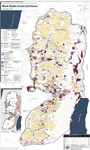
English: Detailed map of Israeli settlements on the West Bank, January 2006. Produced by the United Nations Office for the Coordination of Humanitarian Affairs - public UN source. Map Centre:
العربية: مناطق السلطة الفلسطينية في الضفة الغربية حسب اتفاق أوسلو، حيث يشير اللون الأصفر الغامق (أ) للمناطق ذات السيادة الفلسطينية التامة، بينما اللون الأصفر الفاتح (ب) فهي مناطق ذات سيطرة فلسطينية - إسرائيلية مشتركة، اما اللون الأبيض (ج) فهي مناطق تحت السيطرة الإسرائيلية الأمنية المباشرة. اللون البني يبين التجمعات الاستيطانية الإسرائيلية منذ حرب 1967. بالنسبة لقطاع غزة فهو تحت السيطرة الفلسطينية الكاملة حاليا - بعد انسحاب إسرائيل منه عام 2005 وإخلاء مستوطناتها منه.
|
| Date |
January 2006 |
| Source |
United Nations See: Commons:PDF to image files |
| Author |
United Nations |
 |
This image was uploaded in the JPEG format even though it consists of non-photographic data. This information could be stored more efficiently or accurately in the PNG format or SVG format. If possible, please upload a PNG or SVG version of this image without compression artifacts, derived from a non-JPEG source (or with existing artifacts removed). After doing so, please tag the JPEG version with {{ Superseded|NewImage.ext}}, and remove this tag. This tag should not be applied to photographs or scans. For more information, see {{ BadJPEG}}. |
|
|
Licensing
| Public domainPublic domainfalsefalse |
 |
This image is a map derived from products of the United Nations Cartographic Section. Modified versions of UNCS maps may be used provided that the UN name and reference number does not appear on any modified version and a link to the original map is provided.
Modified UN maps are to be considered in the public domain. This applies worldwide.
The UN maps is an open source material. You can use them to make your own maps. You do not need our permission for that. Please be advised that the UN name and reference number should not appear on any modified map. The UN map is a UN document and cannot be modified. You can say something like "Based on UN map number..." -- Vladimir Bessarabov (UNCS Cartographer), 13 April 05
|
|

|
The permission to use this work has been archived in the Wikimedia OTRS system. It is available as ticket #2006090710013991 for users with an OTRS account. If you wish to reuse this work elsewhere, please read the instructions at COM:REUSE. If you are a Commons user and wish to confirm the permission, please leave a note at the OTRS noticeboard. Ticket link: https://ticket.wikimedia.org/otrs/index.pl?Action=AgentTicketZoom&TicketNumber=2006090710013991
|
File usage
The following pages on Schools Wikipedia link to this image (list may be incomplete):
You can learn about nearly 6,000 different topics on Schools Wikipedia. In 133 nations around the world, SOS Children works to bring better education and healthcare to families in desperate need of support. Have you thought about sponsoring a child?


