
File:Threegorges.png
Size of this preview: 640 × 241 pixels.
| |
This is a file from the Wikimedia Commons. Information from its description page there is shown below.
Commons is a freely licensed media file repository. You can help. |
 |
This map image could be recreated using vector graphics as an SVG file. This has several advantages; see Commons:Media for cleanup for more information. If an SVG form of this image is already available, please upload it. After uploading an SVG, replace this template with {{ vector version available|new image name.svg}}. |
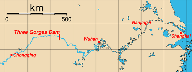
| Description | Map of the location of the Three Gorges Dam, Sandouping, Yichang, w:en:HubeiHubei Province, China and major cities along the Yangtze River. This map was generated using the Generic Mapping Tools (GMT). The coordinates (longitude, latitude) of the cities used are:
|
||||||||
| Date | First version on wp-en: March 27, 2005 | ||||||||
| Source | from en wp | ||||||||
| Author | Rolfmueller (commons) – Rolfmueller (wp-en) | ||||||||
| Permission ( Reusing this file) |
|

Log from wp-en
- del) (cur) 15:14, 6 April 2005 . . Rolfmueller (Talk) . . 2177x935 (50856 bytes) (new version of image (spelling of "Chongqing" corrected))
- (del) (rev) 22:09, 27 March 2005 . . Rolfmueller (Talk) . . 2160x920 (159879 bytes) (Map of the location of the Three Gorges Dam, Sandouping, Yichang, Hubei Province, China and major cities along the Yangtze River. This map was generated using the Generic Mapping Tools (GMT). ==External Link=)
- (cur) (last) 03:55, 14 December 2005 128.175.74.30
- (cur) (last) 03:54, 14 December 2005 128.175.74.30
- (cur) (last) 15:16, 6 April 2005 Rolfmueller (add used coordinates)
- (cur) (last) 15:51, 5 April 2005 Bathrobe
- (cur) (last) 22:09, 27 March 2005 Rolfmueller (Map of the location of the Three Gorges Dam, Sandouping, Yichang, Hubei Province, China and major cities along the Yangtze River. This map was generated using the Generic Mapping Tools (GMT). ==External Link=)
File usage
The following pages on Schools Wikipedia link to this image (list may be incomplete):
Find out about Schools Wikipedia
SOS Children has brought Wikipedia to the classroom. SOS Children's Villages helps more than 2 million people across 133 countries around the world. If you'd like to help, why not learn how to sponsor a child?