
File:DC satellite image.jpg
Size of this preview: 410 × 480 pixels.
| |
This is a file from the Wikimedia Commons. Information from its description page there is shown below.
Commons is a freely licensed media file repository. You can help. |
Summary
| Description |
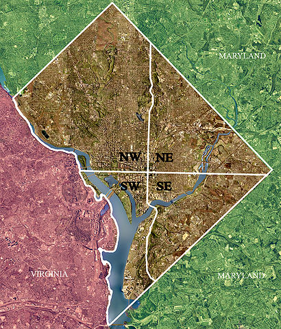
USGS satellite image of Washington, D.C., modified to show territorial boundary and quadrant divisions. |
| Date | April 26, 2002 |
| Source | USGS satellite image |
| Author | USGS, modified by User:Postdlf |
Licensing
 |
This image is in the public domain because it contains materials that originally came from the United States Geological Survey, an agency of the United States Department of the Interior. For more information, see the official USGS copyright policy. български | català | Deutsch | English | español | eesti | suomi | français | galego | italiano | 한국어 | македонски | മലയാളം | Nederlands | polski | português | русский | Türkçe | 中文(香港) | 中文(简体) | +/− |
|
File usage
The following pages on Schools Wikipedia link to this image (list may be incomplete):
Metadata
Schools Wikipedia facts
You can learn about nearly 6,000 different topics on Schools Wikipedia. The world's largest orphan charity, SOS Childrens Villages brings a better life to more than 2 million people in 133 countries around the globe. We have helped children in Africa for many years - you can help too...