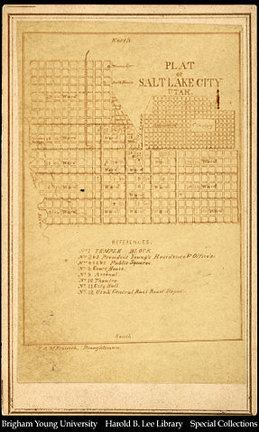
File:Platslc.jpg

 |
This is a candidate to be copied to Wikimedia Commons. Freely licensed or public domain media are more accessible to other Wikimedia projects if placed on Commons. Any user may perform this move—please see Moving images to the Commons for more information. Please thoroughly review the copyright status of this file and ensure that it is actually eligible for transfer to Commons. If you are concerned that this file could have problems with its attribution information and/or copyright status, then remove this notice and DO NOT transfer it to Commons. By transferring this file to Commons, you acknowledge you have read this message and are willing to accept any and all consequences for inappropriate transfers. Repeat violators will be blocked from editing. If you have checked the file and it is OK to move to Commons add "|human=username" to the template so other users can see it has been checked and can help you copy the file to Commons. If the file has already been moved to Commons, then consider nominating the file for deletion or changing the template to {{Already moved to Commons}} If the file can't be moved to Commons because it doesn't fit Common's scope, then use {{Do not move to Commons|reason=Why it can't be moved to Commons}} If you think that a local copy of this file should be kept, then use {{Keep local}}. Consider using {{Keep local|reason=Why the English Wikipedia needs a local copy}} Copy to Commons: via CommonsHelper |
From Library of Congress . Courtesy Special Collections, Harold B. Lee Library, Brigham Young University, Provo, UT 84602.
Photograph of a street map of Salt Lake City called Plat of Salt Lake City, Utah. A street map, showing the blocks and divisions of blocks in the downtown Salt Lake City area produced in the late 1860's by E. Martin, Photographer, East Temple Street, Salt Lake City, Utah Territory.
File usage
Schools Wikipedia facts
Wikipedia for Schools is one of SOS Children's Villages' many educational projects. SOS Children's Villages works in 133 countries and territories across the globe, helps more than 62,000 children, and reaches over 2 million people in total. There are many ways to help with SOS Children.

